


Height Regulation in Residential Districts
PAS Report 237
Historic PAS Report Series
Welcome to the American Planning Association's historical archive of PAS Reports from the 1950s and 1960s, offering glimpses into planning issues of yesteryear.
Use the search above to find current APA content on planning topics and trends of today.

|
AMERICAN SOCIETY OF PLANNING OFFICIALS 1313 EAST 60TH STREET — CHICAGO 37 ILLINOIS |
|
| Information Report No. 237 | August 1968 |
Height Regulation in Residential Districts
Download original report (pdf)
Prepared by Frederick H. Bair, Jr.
Illustrations in this report appeared originally in the May and July-August (1965) issues of Florida Planning and Development.
This report suggests a system of height regulations more closely related to public purposes than are many current limitations. Application of this system on hillsides, to which urban development is increasingly driven, may be particularly helpful. Emphasis is on residential uses, but elements of the approach could be used elsewhere.
Every zoning ordinance regulates height. Many do it very simply and very badly. Common practice starts from a definition like this:
Height of a building. The vertical distance to a flat roof, or in the case of a pitched roof to the mean level between the eaves and the highest point of the roof, measured from the average graded ground level at all sides of the building.
Starting from this definition, which runs into trouble on slopes as will be seen later, limitations usually cover height and number of stories.
Why number of stories? Height sets a relatively close limit on this. Why the lily-gilding, with its embroidering definitions of story, half-story, attic, basement, cellar, and so on? Enabling legislation usually authorizes regulation of number of stories, but this is not a requirement. In residential districts, it is sometimes suggested that limiting number of stories is a way to regulate population density. But there are far more effective means.
In single-family districts, maximum potential number of families is controlled by number of lots, not number of stories in residences. In multiple-family districts, requirements on lot area per dwelling unit or control of floor area ratio establish maximum potential for each lot which can be translated into total potential for the district if anyone wants to engage in this relatively meaningless exercise.
(Even in single-family districts, population rarely approaches the maximum limits allowable under zoning, and in multifamily districts, usually liberally sprinkled with one- and two-family dwellings, neither existing nor probable future population is likely to come to half the total allowed.)
Unless some useful purpose can be found for the control, why not scrap regulation of number of stories and all the involved definitions which go with it?
Next consider what height regulations as such do (or don't do) as generally now written. Usual practice is to set a 35-foot ceiling over vast areas of single-family detached housing. The height envelope is a rectangular box 35 feet high fitting the buildable area of the lot. Its maximum vertical dimension was set (apparently) by mansions still fairly widely extant when zoning was gestating, and in a substantial number of ordinances this prenatal influence still shows its effect, regardless of lot size or side yard requirements. The height limit is the same on a 50-foot lot with 5-foot side yards as on two-acre lots with 25-foot side yards, apparently on the theory that the well-to-do require more light and air than the rest of the population.
The 35-foot height box causes little administrative difficulty because practically no one now wants to build a one- or two-family house higher than that. But it doesn't do what regulations are intended to do on small lots, and it gets ridiculous on large lots in hilly country.
The man with two acres in the hills may be able to go to one part of his lot and build a house 35 feet high "measured from the average graded ground level at all sides of the building" which may be out of sight of the neighbors. Or he may be able to go to a ridge or knoll on the same lot and make the same house loom over the neighbors, with its foundation above the maximum elevation permitted for the roof if the house is built in the lower part of the same lot.
In multifamily height controls we have shown the same regulatory ineptitude, using arbitrarily selected figures without any clear relation to specific purpose. But where one- and two-family height limits give little trouble because the ceiling was so high no one was likely to want to build through it, the situation is different with multifamily. Growing interest in high-rise means that height limits with no demonstrable relation to purpose are likely to be challenged.
Take this situation. District regulations permit 100 feet maximum height. An applicant has 10 acres. Height is the only issue. Number of units is set by lot area per unit, maximum ground coverage by per cent of lot that may be occupied by buildings. The tract, 435 feet wide, slopes down from a highway at a grade of about one foot drop in four to a river 1,000 feet away. A required 50-foot front yard is to be provided next to the highway.
The applicant wants to build a structure 100 feet high "from the average graded ground level at all sides of the building" and 60 feet in width, with its long axis parallel to the highway and set back from it the required 50 feet. On this there is no problem. But he also wants to build a much higher building down near the river. This is denied, and after the board of adjustment finds there is no way it can permit a variance, he goes to court, claiming that as applied to his land, the ordinance is arbitrary and unreasonable. In support, he states that what he proposes to do is in line with the public purposes of zoning, and that ordinance provisions prohibiting what he proposes to do defeat such purposes.
His major reasons for seeking greater height at the river site are to reduce ground coverage in order to preserve established forest, to improve the view of building occupants, and to avoid impeding view from other structures on his own and adjoining properties by making the building slender and tall rather than massive.
Ignoring his other persuasive reasons, consider height alone. Using 0 as the elevation at the buildable area boundary by the river, the upper buildable area boundary is at 225 feet. At the upper boundary, the roof of the highest building permitted would be at elevation 325, the base 125 feet above the roof of the highest building permissible at the river boundary.
How would the court be likely to decide on his plea that the lower building be allowed to go to 175 feet (still 50 feet below the base of the upper building)?
With this as background, what can be done to make height regulations more meaningful?
Some Basic Assumptions
Height regulations have these principal purposes:
(1) Protection from fire hazards. Height above capability of normal fire fighting equipment should require certification by fire officials that specialized construction and facilities in the building will be an adequate supplement.
(2) Protection against aviation accidents. Proposed buildings with location or height constituting potential hazards to aviation should be controlled by special zoning or cleared by the FAA.
(3) Protection of view. This is a sticky problem, partly because it is a matter of degree. Public interest is not considered involved where a low building cuts off a major part of the view of the neighbors. How much of what kind of view must be blocked for how many people before public action is justified? Some special techniques will be suggested later. (Also, see View Protection Regulations, PAS Report No. 213, August 1966.)
(4) Protection of the character of the neighborhood. This subjective matter is likely to involve heated emotions and extensive nonlogical reasoning. In one case, large-lot, single-family detached types from an area three miles away rose in embattled ranks to fight a proposed high rise — which none of them could have seen — because it would be out of character in their neighborhood — or, to dig a little deeper, because people who live in high-rise buildings might be different. Never mind the logic — the argument prevailed. "Character of the neighborhood" is likely to be an important issue where high buildings are proposed in locations surrounded by low buildings, and regulation requires very careful handling.
(5) Protection of light and air is familiar ground. Present regulatory patterns are not only crude but almost dishonest if protection of light and air is of equal importance for everyone, and if this is a principal purpose of height and yard combinations. Only if character of the neighborhood is added into the combination does it make sense to say that a 35-foot height requires a 15-foot side yard in one district, but only five feet in another.
Beginning with the Lot
Starting with the lot, principal public concern is with parts of residential buildings closest to those on adjacent lots. This is usually at the inner edges of side yards, which becomes one critical point in providing light and air between buildings. Height here should be kept low.
If an approach now gaining wide acceptance is used, the rear yard dimension will be the same as that of the side yard and subject to the same limitations as to structures. This gives a larger buildable area, allowing flexibility in design. Lot coverage limitations prevent overbuilding. Thus the inner edge of the rear yard may also be a critical area in providing light and air, and again height should be kept low.
At the front, light and air for relatively low buildings is adequately provided by the front yard and the street. Except as influenced by limitations at the sides, it seems logical that full height should be allowed at the buildable area boundary adjacent to the front yard. For very high buildings, as the street and front yard dimensions become inadequate to provide sufficient light and air in lower stories, further adjustments may be necessary.
Emerging from this is a height envelope different in form from the rectangular box now commonly used, and better adapted to public purposes. The proposed approach includes three variables, heights at outer edges of the buildable area, height limiting planes leaning inward over the lot from the upper edges of the buildable area planes, and maximum height (if set) over portions of the lot not otherwise enclosed. On level lots, planes leaning inward from lot boundaries could be used, but because it is desirable in many places to have regulations adaptable to either level or sloping land, the buildable area limits are preferable, for reasons which will appear later.
At side and rear edges of the buildable area, height limits in areas with low detached residential structures should probably be considerably lower than general limits now in use, and should be directly related to the minimum dimension of side and rear yards. Using twice the required minimum width of these yards (as an example), and allowing this for height at the inner edges of the yards (outer edges of the buildable area boundary), the result would be a height limiting plane, or light plane, at a 45 degree angle. If this makes sense in terms of light and air, it would be used to run inward over the buildable area. Given a 5-foot yard requirement, then, the first element in the control would be a 10-foot limit at buildable area boundaries near side and rear lot lines. The second element would be the 45 degree plane leaning inward from the 10-foot height thus established. And if an absolute ceiling is established for the district, it would take effect when it intersects the light planes as they slope inward over the lot.
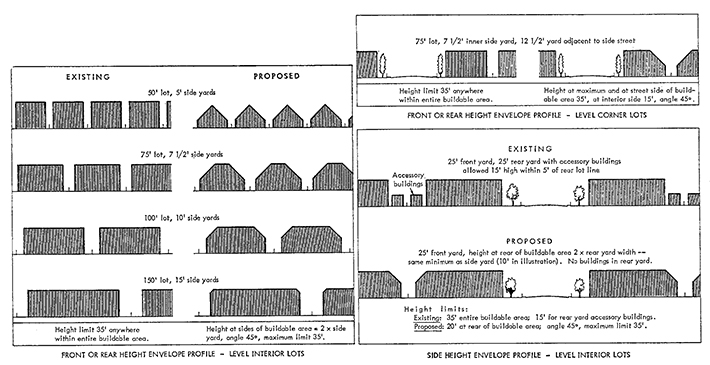
The diagrams above compare conventional height limits and their effects with the suggested method. It should be noted that the outlines indicated are merely envelopes within which portions of buildings could be erected, and are not proposed building forms.
To vary the pattern, height at edges of buildable areas, light plane, or maximum height over any portion of the lot could be changed. As an added refinement, length of building might be considered in setting side-yard requirements. This is a technique used by FHA in controlling yard width requirements for multifamily structures. Where a building is very long, the effect on light and air in adjacent yards is such that FHA suggests adding one foot to the yard for each 15 feet of run of the wall.
Lots Which Are Not Level
Having established certain principles for height regulations on level lots, the next problem is to adapt them to lots which aren't level. In hill country, lots can have a bewildering variety of cross sections, particularly when large lots are required. The larger the lot, the greater the variation between its high and low points, and the greater the probability that it will not be a simple sloping plane.
In the hills, application of regulations intended for level lots leads to complications, as indicated by the examples given earlier. Slopes, high spots, and low spots blindly impose penalties and award bonuses with total disregard of public purposes, and larger lots in rough country multiply possibilities for too much or too little limitation. Potentials of natural topography may be magnified or reduced if height regulations are based on "the average graded ground level at all sides of the building." The average may be difficult to determine with irregularly shaped buildings or irregularly graded sites, and in any event has no fixed or determinable relation to what may be built on adjacent lots.
The problem is to come as close as possible to equating regulations for lots which aren't level with those for lots which are.
On level land, the light plane seems to be a central feature in the kind of height regulations applying to most residential areas. There is no practical way to protect many distant views in the flatlands — a one- or two-story building blocks off views of the distance from other one- and two-story buildings or from ground level just as effectively as a 10-story building.
In hill country, in addition to protecting light and air, it is possible to give some protection to view and at the same time add flexibility in building form which may be helpful in overcoming terrain problems. In locations where development costs are high (as they are likely to be in rough terrain), this by-product is likely to be of considerable importance. The same regulatory devices are used as on level lots, and the same specific heights and angles may be used, but they are applied in a manner adapted to hilly locations.
From the front or rear, the diagrams on the next page indicate the elements in regulation and how they apply on sloping lots. In the illustration marked "Detail," Plane I is the ground level, shown here as conveniently regular. What to do about irregular ground is discussed later. To establish principles, this is a smooth plane with a 15 per cent slope. At the edges of the buildable area, the lines D–F and E–G represent heights of 20 feet, twice the width of the required side yard.

Plane II, the dashed line running from D–E, is not a height-limiting element, but is used to construct the 45 degree light planes 1 and 2. On level ground, Plane II would be horizontal. Here it is parallel to the slope.
Plane III, establishing ceiling height over the part of the lot between B and C (where the ceiling plane intersects the light planes) is constructed as a horizontal line from point A, 35 feet above F. The "view line" running through A–G is the level at which a building built to Plane III would obstruct horizontal view from an uphill building.
Why set the 35-foot height plateau on the basis of the highest buildable area boundary? With the slope indicated, this places actual height above ground at B at about 38 feet, at C at 44 feet. On a level lot, the ceiling is a flat 35 feet. Aren't the greater heights inequitable? To some extent yes, but not in the way which might be anticipated. Height limitation is a means for relating heights on adjoining lots as well as for controlling height on one lot. To be "equitable" in the sense of permitting the same absolute heights on adjoining lots, either the height limit on the down-slope lot would have to be raised or that on the up-slope lot would have to be lowered.
As the diagrams on relationships indicate, the ceiling heights down-slope will always be lower than those up-slope. This is important in preserving at least residual views, since principal views from hillsides are generally downhill, and greater height of structures uphill is not a substantially adverse influence.
The proposal checks out as reasonable in another way. Under the "average graded ground level at all sides of the building" approach, there would be nothing to prevent terracing to allow at least as great a height as is allowed here. If height were sought by this means (as it might be where view is involved) the effect would be major disturbance of terrain, which should be avoided, not encouraged.
Making the light plane run 45 degrees from Plane II instead of 45 degrees from the horizontal moves the higher parts of the building farther from the uphill line, nearer to the downhill, and doesn't have substantial adverse effect on light at ground level. Considering the probable location of the most important views, the effect of perspective, and the difficulties in achieving the unattainable, this seems the best way to handle the detail. The farther a high point is from the observer, the less horizon it blocks; hence, moving B farther from the uphill buildable area line is desirable. Lowering height at C, or moving C back toward the center of the lot, will not improve the view uphill, which will remain a view of a building, not a landscape, even if the building is only 20 feet high.
As indicated in the upper diagram on relationships, the light plane for the lower building intersects a wall for an upper building a short distance above its base — but not high enough to affect light at window level. The gain in view protection seems to off-set the minor difference in light.
The bottom sketch in the diagram shows front or rear height envelope profiles on a variety of slopes (without implying endorsement of streets at the grades indicated). Even across the short dimensions of the lots, buildings on most could be shaped so that portions might take advantage of views. Since buildings would not occupy the entire envelopes outlined, actual views would be better than those indicated here.
From the side. On the lengthwise exposure of lots, with streets and front yards making the light plane unnecessary at the front of buildings, the rear applies the plane because relationship to adjoining sites is potentially the same as at the sides. Because of the length of run involved, the difference between height at the upper and lower buildable area boundaries is considerably greater when the slope runs down the lot than when the slope runs across it.
In the diagram on side height envelope profiles, the detail illustration at the top indicates a 20-foot difference between the 35-foot height limit at A over F and the 55-foot height which would be allowed at C. Height profiles on varying slopes as diagrammed indicate some of the possibilities for retaining views. The uphill end of the profile from the front or rear is a truncated pyramid on a relatively low base. There are spacings between buildings as set by yard requirements. Few buildings will fill the entire height envelope. With good site planning related to important vistas and to the kind of height regulation proposed, it should be possible to design for view.

One interesting effect of the application of the proposed techniques appears at the top of the hills. Buildings on hilltops are kept low, so that they do not protrude against the skyline.
Application in Districts with Mixed Housing Types
These techniques are well adapted for districts permitting mixtures of residential types, both in conventional lot-by-lot zoning and planned developments. According to terrain potential and lot shapes and sizes, there will be areas suitable for single-family detached residences, town houses, and garden and other apartments even where the height at the top end of the buildable area is kept at 35 feet. On long lots, maximum height allowed at the lower end might rise to 55–60 feet or more because of the way the envelope is constructed. Design of hillside apartments would permit walk-in, walk-up, or walk-down apartments in multistoried structures without entrances at various levels.
If high-rise buildings which could not be built within these limits are to be permitted, special regulations will be necessary, trading extra height for reduced land coverage and increased control of impediment of principal views. This can be a very good bargain for the public. Added setback from property lines reduces the arc of total view obstructed, and the extra open space is a bonus if properly landscaped and protected against sea-of-cars appearance.
Regulatory Language
Moving from theory to practice, here is some regulatory language along the lines indicated by the previous discussion, taken from a zoning ordinance proposed for the City and County of Honolulu:
410. Height of buildings and other structures.
410.1. Intent. It is the intent of these height regulations to secure safety, to provide adequate light and air, and to protect the character of districts and the interests of the general public in important views. To accomplish these purposes:
410.2. Fire and safety requirements.
410.2.1. Fire protection. No building exceeding 40 feet in height above grade shall be erected without certification from the Fire Chief that such building, as proposed to be located, constructed and equipped, and particularly occupants of upper stories, can be properly protected in case of fire. In the case of structures other than buildings exceeding 40 feet in height, the Planning Director may require such certification where he finds that there is substantial fire danger to surrounding property.
410.2.2. Aviation hazards. No building or other structure shall be located in a manner or built to a height which constitutes a hazard to aerial navigation. Where a structure is proposed in a location or to be built to a height which the Planning Director believes may be hazardous to air traffic, such structure shall not be erected without certification from the Federal Aviation Agency that as proposed to be located, constructed and equipped, it will not constitute a hazard to air traffic.
These provisions go directly to the point on the elements covered. The 40-foot figure in the fire protection section is lower than might be used in many jurisdictions. "Height above grade" is appropriate here because it relates to use of fire equipment. On both fire and aviation details, the planning director (who is administrative official in charge of zoning also) is charged with making referrals to appropriate experts in the circumstances indicated.
410.3. Height limits for buildings and other structures are hereby established generally by height envelopes, for which formulas in the schedule of district regulations prescribe maximum height at outer limits of buildable areas, inclination of light planes leaning inward over the lot, and in some districts maximum height over the central portion of the lot. No portion of any building or other structure shall extend through any portion of such height envelopes except residential chimneys, residential radio or television antennas, spires, flagpoles, or monuments otherwise approved for erection, provided however that smokestacks, water tanks, radio and television transmitting towers, relay towers and the like may protrude through such height envelopes if they do not exceed in height the distance to the nearest lot line, except where property borders permanent open space other than streets and such space is not likely to be occupied by substantial numbers of persons.
The next provision includes a method for computing a base plane for height measurement. The base plane can be readily determined and applied, with a little practice, and works equitably on level land and on minor or steep slopes with or without irregularities. It encourages use of natural terrain without excessive grading, allowing greater heights in low areas and holding height down on natural high points within the buildable area. Thus if height permitted at a particular point is 45 feet above the base plane and the actual level of the ground is five feet below it, actual permitted height of a portion of a building at that point would be 50 feet.
On large tracts, application of the technique sometimes doesn't work out as well as might be hoped. Hence provision is made here for construction of envelopes on lots with one acre or less, and at 410.5 for breaking down larger tracts into workable components.
410.4. Construction of height envelopes for lots containing one acre or less shall be as follows:
410.4.1. Base plane. Establish a base plane (Plane I) for the buildable area. Where the ground surface is a regular plane, it shall be considered the base plane. Where the ground surface is irregular, the base plane shall be constructed as follows:
(a) Establish a straight base line from the highest existing point to the lowest existing point on the buildable area boundaries. If such points are abrupt irregularities, such as sharp ridges or ravines, average elevations along buildable area boundaries within 50 feet of actual highs or lows shall be used, and the Planning Director shall select point of beginning or termination of the base line within the portion of the buildable area boundary used for averaging.
(b) To locate elevations of the base plane at any point within buildable area boundaries, extend horizontal lines at right angles to the base line (projected as necessary beyond buildable area limits to permit computations for the entire buildable area).
The computation involved in step (b) is a simple matter of proportion. If the base line is 400 feet long and drops 40 feet from the highest to the lowest point, a right-angle line intersecting it 100 feet from the top would be considered to intersect points 10 feet below the point of beginning elevation on the upper buildable area boundary, or 30 feet above the lower point of beginning.
410.4.2. Establish a second plane (Plane II) parallel to Plane I and at such distance above it (measured 900 from the horizontal) as is indicated in the schedule of district regulations for maximum height at outer lines of buildable areas. For some districts, this height is stated directly as the Plane II height. In others, height is related to width of the adjoining street.
410.4.3. Light planes. Establish light planes leaning inward over the buildable area at angles specified in the schedule of district regulations, beginning from lines established by vertical projection of buildable area boundaries to intersect with Plane II. Base lines from which the angles of such planes shall be computed shall lie within Plane II and extend at right angles from the vertical projection of the buildable area boundaries, Such light planes shall extend inward only from buildable area boundaries as specified below:
(a) In P-l, AG, R, A, and H districts, from Plane II above side and rear buildable area boundaries other than those adjacent to streets or permanent open space 50 feet or more in width.
(b) In B-1 districts, no light plane is established and full height is permitted over the entire buildable area.
(c) In B-2, B-3, B-4 and I districts, the light plane is established for portions of lots adjacent to streets at angles established from center lines of adjacent streets.
(d) In all B or I districts, lots at the edges of such districts are affected by light planes established for certain adjoining districts as specified in the schedule of district regulations.
Light planes so required shall extend inward over the lot until they meet over the lot, extend through vertical projections of buildable area boundaries not involving light planes of their own, or reach Plane III, described below, with height within the envelope controlled by the lowest of the heights enclosed by such planes.
Detailed provisions above indicate a wide range of possibilities. In preservation, agricultural, residential, apartment, and hotel districts, light planes start from above side and rear buildable area boundaries, in B-1 districts there is no light plane limit, in B-2, B-3, and B-4 the only light plane involved starts from the center line of the street, and in B and I districts, a combination of the provision here and others in the schedule provide for transitional height control along certain district boundaries. As another variable which might escape notice without comment, in some districts there is no maximum height limit except that established by the light planes as they intersect over the buildable area, allowing height to be related to lot dimensions.
410.4.4. Establish Plane III (in districts in which a maximum height limit is set) running horizontally over the lot and beginning from such elevation above the high point used in establishing the base line as is specified in the schedule of district regulations for Plane III, or for maximum height in the district.
410.5. Construction of height envelopes for lots containing more than one acre shall be as above, provided, however, that where by reason of extent or terrain it is impracticable to apply the rules above to the lot or tract as a whole, the Planning Director, for administrative purposes, may divide the total area of the lot or tract into portions adaptable to the rules above. In so doing, lines other than property lines bounding portions into which the lot or tract is administratively divided shall be treated as boundaries of buildable areas in establishing Planes I and III for each of such portions of the lot or tract, but Plane II and the inclined portion of the height envelope shall not be established with respect to the administrative boundaries unless the Planning Director shall find that public purposes like those prevailing at buildable area boundaries along the perimeter of the lot or tract, and particularly maintenance of principal views, require the application of such height limitations.
Lot Coverage as Related to Slope
As a miscellaneous detail related to height control on hillsides — and useful for other purposes — the Honolulu ordinance relates per cent of the lot which may be covered by buildings to the slope of the base line. Thus in the very low density agricultural areas, maximum lot coverage on slopes less than 20 per cent is 20 per cent, with a declining scale dropping to 2 per cent lot coverage on slopes of 40 per cent and over. Ranges for residential and hotel districts are from 30 per cent to 50 per cent lot coverage on base line slopes under 20 per cent with coverage on slopes of 40 per cent or over held to 5 per cent in any such district.
The effect here is to push for reduction of land occupancy (and disturbance of natural terrain and vegetation) on steep slopes. The limitation dovetails with height controls allowing higher buildings in portions of steep-slope lots.
(As a concluding note, with regulations like those suggested here, the applicant who wanted to build the l75-foot high rise in the riverfront portion of his sloping lot would be able to do so without going to court about it.)
Copyright, American Society of Planning Officials, 1968.