Planning November 2018
The Future of the Dammed
Higher temperatures and lower water levels are causing states to rethink 20th century infrastructure.
By Allen Best
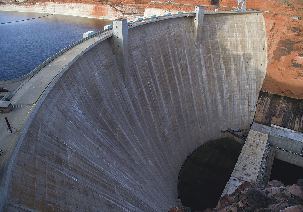
The hundred feet of bleached sandstone walls of Glen Canyon exposed by the receding waters of Lake Powell starkly illustrates the conundrum of water infrastructure in western states and the effects of a changing climate. Completed in 1963, the construction of Glen Canyon Dam across the Colorado River in the Utah desert was a landmark in the resolute 20th century effort to harness rivers of the West to provide water for irrigation — and, indirectly, for expanding cities — and hydroelectric power for both.
Today, the dam delivers 1,320 megawatts of low-cost, low-carbon hydroelectric generation to farms and homes as far away as Nebraska. The reservoir, the nation's second largest, is among 260 on the Colorado River and its tributaries that store and regulate flows in a vast plumbing system supporting a population of 40 million people from Denver to San Diego — cities outside of the river basin itself — and some of our nation's most productive agricultural areas.
Population growth alone puts pressure on this 20th century infrastructure. Southwestern states grew 37 percent from 1990 to 2010, with no end in sight. Now comes clear evidence of climbing temperatures and hints at shifting precipitation patterns.

Glen Canyon Dam on the Colorado River in April 2017. The dam is 15 miles upstream from Lees Ferry, Arizona. Photo by Alexander Stephens/courtesy Bureau of Reclamation.

Lake Powell, as seen from Glen Canyon's Carl B. Hayden Visitor Center observation deck. Photo by Alexander Stephens/courtesy Bureau of Reclamation.
Lake Powell, nearly full at the start of this century, is projected to end 2018 at 43 percent of capacity after another year of decreased runoff on the Colorado River. Subpar runoff has been more common than not this century, but unlike droughts of the past that were caused by reduced precipitation, some climate scientists say that warming temperatures have caused more than half the declined flows, due to evaporation and transpiration (when plants absorb water through their roots and then emit water vapor through pores in their leaves).
But Powell is just a chapter in a larger story. It is operated in tandem with Lake Mead, the nation's largest reservoir, which is 300 miles downstream, below the Grand Canyon. Together, the two reservoirs can store 50 million acre-feet of water. (Smaller reservoirs in the seven basin states can store an additional 10 million acre-feet.)
But this overall bank account has been ebbing toward worrisomely low balances; this autumn, it receded to 28.4 percent of full capacity, among the smallest since the modern water infrastructure was completed last century.
Studying the numbers, some have raised the question of whether Lake Powell is needed at all and suggested that just Lake Mead will suffice in a hotter, likely drier Southwest of the future.
But adequacy of water infrastructure as the climate changes is not just a question for the Colorado River. It applies to the Columbia River of the Pacific Northwest, the Rio Grande of New Mexico and Texas, and California — all homes to giant water infrastructure. A nagging, and still unanswered question, remains: Will infrastructure created during the 20th century continue to serve the needs of the 21st century? And if the answer is no, what can we do about it?
Snowpack in the Watershed
The snow percentile image displayed below indicates where the snow measurement ranks in the historical record (from 1981 to 2010) for each recording site as of April 1, 2018. Many sites are depicted with red dots, indicating the lowest values on record for this time of year. See more at bit.ly/2DFBK3v.

Source: NRCS.
Changing times, temperatures
From beginning to end, cities, irrigation districts, and states ambitiously built dams, canals, and tunnels throughout the 20th century. The U.S. Bureau of Reclamation was the primary federal dam builder; its mission was to develop water storage and irrigation infrastructure to allow settlement of the arid western states.
Hoover Dam, completed in 1936, was a partial exception, driven by Los Angeles's thirst for hydroelectric power, in addition to regulating flows for irrigation and controlling floods. In mid-century came the construction of Glen Canyon and other dams on the upper Colorado River Basin.
The last giant push, the Central Arizona Project, was authorized by Congress in 1968 but not completed until 1994. It delivers Colorado River water 337 miles through a concrete-lined canal to Phoenix and Tucson.
Today, rising temperatures threaten to upset the hydrological applecart. The U.S. Bureau of Reclamation, in a 2016 report to Congress, found that the western U.S. has warmed roughly two degrees Fahrenheit since 1895, compared to 1.3 degrees to 1.9 degrees F in other parts of the country. It will get worse, the report noted, with another five to seven degrees F of warming through the 21st century if greenhouse gas emissions go untamed.
This warming has profound consequences. Longer summers will demand more moisture for both lawns and crops; more rain will fall during winter atop snow, increasing the flooding potential for higher-elevation regions of the high Rockies by 200 percent, according to a study released in August; droughts will be deeper; and precipitation events when they happen, will be more intense.
Runoff patterns have already shifted. Spring comes earlier nearly everywhere — posing problems for water infrastructure in the West, which was mostly created with the assumption of a large snowpack that melts in the summer months. But a study by Oregon State University's Philip Mote and others found that more than 90 percent of snow monitoring sites with long records across the western U.S. had dramatic declines in the water content of April 1 snowpacks. Altogether this loss, said the paper published in the journal Nature, was comparable in volume to the water in Lake Mead.
"The magnitude of these changes relative to the built storage reservoirs, and the certainty with which continued warming will lead to continued declines at a similar or increasing rate, illustrates the immense challenge facing Western water managers," Mote wrote.
Mote's report warns that those solutions will likely require some heavy lifting by water managers and public officials. "Patterns of water use that became established (even entrenched) during the climate of the past cannot be changed without intense political effort owing to large cultural, economic, and infrastructure investments in the status quo ante. ... Solutions will have to lie primarily in the linked arenas of water policy (including reservoir operating policies) and demand management."
"We need to do a much better job of integrating [this] new reality into our water management decisions," says Heather Cooley, director of the water program at the Pacific Institute in Oakland, California.
Shrinking Water Levels in Lake Powell
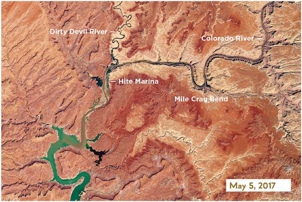
Changes in the northeastern reaches of Lake Powell are documented in this series of natural-color images taken by the Landsat series of satellites between 1999 and 2017. The Colorado River flows in from the east around Mile Crag Bend and is swallowed by the lake. At the west end of Narrow Canyon, the Dirty Devil River joins the lake from the north. (At normal water levels, both rivers are essentially part of the reservoir.) At the beginning of the series in 1999, water levels in Lake Powell were relatively high, and the water was a clear, dark blue. The sediment-filled Colorado River appeared green-brown. To see the complete series go to: earthobservatory.nasa.gov/WorldOfChange/LakePowell.


Photos courtesy NASA.
New approaches
Higher rates of evaporation caused by warmer temperatures have played into current conversations about water infrastructure, including the debate about Lake Powell. Environmentalists never did like that the reservoir inundated 186 miles of lovely rust-colored canyons. In 1975, even before the reservoir had filled, Edward Abbey had mischievously imagined the dam fracturing in his novel The Monkey Wrench Gang. Critics say that the reservoir has made the Colorado River through Grand Canyon National Park a beautiful and sometimes dangerous irrigation ditch.
Arguments in recent years have pivoted more on climate change. Given the declined flows in the Colorado River Basin, could one reservoir — downstream at Lake Mead — suffice? A canyon could be restored and there would be evaporation from just one reservoir, not two. An average six feet of water per year evaporates from the surface of Lake Powell, a little less than downstream at Lake Mead in the Mojave Desert.
Dan Beard, a former commissioner of the U.S. Bureau of Reclamation, has emerged as the most prominent advocate for removing Glen Canyon Dam. The dam, he says, was conceived during a different time. "Seventy-five years ago, there were no American environmental laws to protect the Colorado River, the science of climate change did not yet exist, and the flow of water in the Colorado River was much higher," he wrote in an op-ed published a few months ago in the Denver Post.
"There is no new water to fill these facilities, and there won't be because of the inevitable impacts of climate change," he wrote.
Evaporation is also an issue in New Mexico. The state's largest reservoir, Elephant Butte, located in the desert south of Albuquerque, serves as primary storage for the Rio Grande. Climate projections point toward a much hotter and drier future for the river basin. Might that future better be served by more reservoirs in higher-elevation and cooler locations, such as at the river's headwaters in Colorado? That idea was proffered by U.S. Sen. Tom Udall — whose father and uncle were influential in creating this 20th century infrastructure — at a conference in Santa Fe this past spring.
With river flows declining, there have been calls for more storage. But nobody realistically expects another Grand Coulee in the 21st century. The good sites for dams have been taken, and the environmental impacts are better understood, or at least more strongly argued.
Anne Castle, who was the Interior Department assistant secretary for water and science in the Obama administration for five years, sees value in "small strategic storage that will allow more efficient utilization of the water we have." In some cases, this merely requires retrofits. She cites the example of Fontenelle Reservoir, located in southwestern Wyoming.
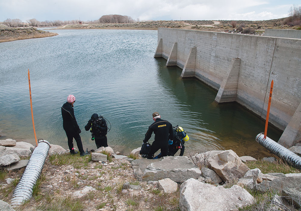
Loose stones, called rip-rap, were originally used to fortify the upper portion of the Fontenelle Dam, making it more resistant to erosion from waves, but not the lower portion (largely because the dam's designers never expected water levels to get that low). That means water levels cannot currently be drawn down below the reinforced section, limiting the amount of usable water storage. To remedy this in the likelihood of worsening drought conditions, the state wants to reinforce the lower part of the dam wall.
"You can get a lot more usable storage without having to build anything new," says Castle.
Groundwater recharge takes the burden off surface storage, says the Pacific Institute's Cooley, allowing reservoirs to be used more for flood control. "Groundwater recharge also diminishes water lost to evaporation. It will help us deal with more extremes in the future," she says.
Cooley also says dispersed and smaller water storage would be more resilient in case of natural catastrophes, such as earthquakes. And in California and elsewhere, demand-side management and conservation programs can be leveraged even more to make communities less reliant on big water projects. For example, while some state and local water laws limit water reuse, San Francisco now requires all buildings of 250,000 square feet or more to institute water reuse within the building.
Not every strategy is appropriate in every location, Cooley says, and none of them are particularly easy. "But I think they will be necessary to meet our 21st century challenges."

Divers and marine operations specialists perform an inspection at Fontenelle Dam in Wyoming. Photo by Alexander Stephens/courtesy Bureau of Reclamation.
Who will foot the bill?
Beyond the question of what infrastructure makes sense in the 21st century, there's also the question of who will maintain aging dams, canals, and other delivery systems. The federal government and its generous piggy bank largely disappeared after the dams were built. Castle, the Washington veteran, doesn't assume that "federal investment in water will never go up again." But neither is federal aid certain.
That question of funding faces Colorado's Mark Harris, the general manager of the Grand Valley Water Users Association. The association administers a small diversion dam on the Colorado River built in 1916, along with 55 miles of canal and 150 miles of pipe and smaller ditches, called laterals. This infrastructure delivers irrigation water to 23,340 acres of vineyards, peaches, and other agricultural products around Grand Junction. Increasingly, this water gets transferred to new suburban and exurban homes.
Harris says Grand Valley's water customers mostly accept the challenge of climate change, recognizing that existing infrastructure, in addition to being a century old, may not entirely be adequate for changing pressures. But new concrete and reconfigured headgates are not the only issue.
"We have 19th century (water) laws, 20th century facilities, and 21st century expectations," Harris says. Physical infrastructure is not the only thing that must be updated, he says. "There is also the rehabilitation and evolution of our thinking."
California provides a case study because of its wild extremes: drought from 2011 to 2014 that was deeper than any in the state's recorded history followed by a winter in 2016–2017 that, in the state's northerly sections, was the wettest ever.
Floodwater threatened to take out the Oroville Dam, forcing evacuation of 200,000 people.
"These changing conditions threaten an already deteriorating infrastructure system, which traditionally has been planned, designed, and engineered based on historical climate and weather data and trends on the assumption that the past is a good predictor of the future," reads "Built to Last," a December 2017 report about California water infrastructure by the Union of Concerned Scientists.
The scientists call for "climate-smart" infrastructure as California spends the $7.5 billion for various water projects approved by voters in 2014. (Voters this month will be asked to approve another $9 billion bonding capacity). There have been proposals for more big dams, but they have lost out to small storage, including aquifer recharge projects.
Beard, the now-retired boss of federal dams who supports tearing down Glen Canyon Dam, says water solutions for western communities need to be more local. It starts, he says, with realistic prices being assigned to water. In many cases, water now is essentially free. We pay for its transportation, but not for the water itself. He further points out that many water proposals even during the 20th century, such as making dams higher, faltered when those who would benefit were asked to pay.
The answers for both population growth and climate change, he says, lie closer to home, not in trying to tap new resources far away.
Allen Best writes about water in the Great Plains and western states frequently from a base in Denver.
Resources
An interactive map displays Lake Powell's water levels on a daily basis since 2016. powell.uslakes.info/Level eo.com/264665600
National Geographic's Short Film Showcase highlights the 1956 efforts to document culturally significant sites and side canyons that would be flooded by the Glen Canyon Dam. bit.ly/2zDIMS7


