Jan. 7, 2022
This story is part of Planning's "The Billion Dollar Curb" series. Using data from all 50 states and the latest tech solutions, this multi-part roadmap offers equitable and lucrative plans, policies, and pricing strategies to help communities of all sizes better manage the curb. Read the first and second installments.
"Curb management" is the hottest term in transportation right now. Much of the current conversation is focused on the exciting parts: technology, delivery reservation systems, parklets, camera monitoring, passenger loading zones, scooters. In other words, transportation glitz and glamor.
We need that glamor because it energizes stakeholders, brings investments, and moves policy forward. But we also need to do the work to create substance. Failure to set standards and priorities will continue to undervalue the most prime piece of public real estate in our cities and exacerbate all the inefficiencies and problems that typically result from this undervaluation.
Over the course of Planning's "The Billion Dollar Curb" series, we've chronicled how cities have undervalued their valuable curbs by turning them into private-vehicle storage — and lost out on billions in revenue as a result. That's largely happened because cities don't have priorities in place to guide use of the space, particularly as it becomes more crucial to the success of a variety of industries.
That's where a curb-management framework comes in. This living document guides a crucial prioritization process for how the curb functions. It also provides a lens for creating policy, treatments, and monetization, plus help cities better evaluate technology and partnership opportunities.
From financing mechanisms to zoning and new tech to troves of data, cities have access to a variety of tools and resources that can help them create and meet goals to control the curb in ways that balance public and private sector needs. Developing the framework is the hard work. It might not be as glamorous as cameras or geofencing, but it will ensure curb access is prioritized to make places more equitable, improve the level of service for everyone, support local business, advance mobility and climate goals, and create a sustainable revenue source.
1. Set goals
Drawing on citywide planning and policy initiatives, as well as stakeholder and community input, the first step in developing a curb-management framework is defining the goals for curb output to guide how to prioritize the space. Goals should be in line with citywide priorities for mobility, equity, access, livability, sustainability, safety, economic development, cost recovery, and more.
Education and outreach should occur throughout the development of a curb-management framework, but it is especially important at this stage. On-the-ground user experience of the curbside from multiple perspectives and modes can make real connections to data analysis and evaluation — support necessary to help pass new policy.

Bikes, deliveries, pedestrians, ride-hailing, and private vehicles all vie for limited curb space. A framework can help balance these uses and needs. Photo by Tada Images/Shutterstock.
Once goals are set, curb functions or guidelines for curb uses along a block or corridor, should be determined. For example, curb functions used by the cities of San Francisco and Seattle include: access for people, goods, and commerce; public space and services; storage for vehicles; movement; greening; space activation; and mobility.
2. Identify land use
Because adjacent land uses should guide how curb functions are allocated on a block and along a corridor, the next step is categorizing land-use types. San Francisco, for example, has identified six:
- Low-density residential consisting mostly of single-family homes
- Mid-to-high-density residential with apartments and businesses — like corner stores and coffee shops — that serve residents
- Neighborhood commercial with a mix of residential and commercial activities such as restaurants and small-scale retail
- Downtown with areas of high density and intensity — predominately office, retail, and commercial, and some high-density residential
- Major attractor such as an arena, hospital, or university campus
- Industrial/production, distribution, and repair
With curb functions set and land uses categorized, cities can determine priorities and set curb typologies based on the adjacent land uses and overall goals for curb output. For example, if a goal for curb output is to reduce congestion and increase access, a busy commercial-corridor typology with lots of retail and restaurant activity should prioritize access for people and movement.
3. Create a digital curb inventory
To determine if a location is a good candidate for curb-management planning, we need to know how much curb space is available and how the space is regulated and used. We also need to create a baseline productivity metric determined through an understanding of dwell times, turnover, and occupancy. Typically, curb-management policies are most beneficial and necessary in locations and around land uses with a lot of activity, like commercial centers, entertainment districts, and mixed-use areas.
Few cities have an organized inventory of how curbs are regulated or used. More typical is an annual parking survey or some documentation on curb regulations that may or may not have been updated with changes over time.
In the past, to collect a curb inventory, we needed to walk each block to detail the location and regulation of every sign, curb cut, and fire hydrant. The inventory then likely sat in an Excel database in one city department. Now, given that new curb dynamics involve multiple agencies, private-sector partners, and changing demands, we need to go beyond a static inventory. A digital curb inventory, for example, can help cities visualize, analyze, and update curb strategies and regulations and communicate with the private sector so they can manage commercial delivery fleets, park scooters, and guide ride hailing in real time.

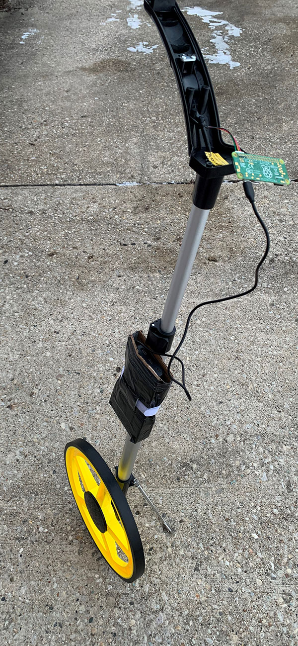
The Curb Wheel can be used to create digital inventory. Images courtesy of Walker Consultants.

The non-profit Shared Streets is developing an app to work with the Curb Wheel.
Companies like Populus and Coord provide tools and apps to capture curb and sign images and pull together existing data (those old static Excel sheets) into standardized formats. The non-profit Shared Streets is also developing "Curb Wheel," a wheel and phone app cities can use to create a digital inventory.
With multiple curb-inventory and planning products on the market, we need a standard data specification so cities can work and plan together — and the private sector can talk across cities with one language, similar to public transit's General Transit Feed Specification. The Open Mobility Foundation is developing a standard data specification for curb regulations, events, and metrics. The data specification will provide a uniform way for cities to identify curb uses, pull in real-time data from third parties like parking meters or enforcement systems, and determine statistics on curb uses such as parking occupancy, ride-hailing dwell times, and scooter parking.
When inventorying the curb, we also need to rethink how we itemize the space. Digital curbs won't be numbered as spaces, but more likely measured in terms of linear feet, with changes in use throughout the day and week based on city priorities and demands.
4. Understand use
Once the curb is inventoried, we need to understand how it is used throughout the day with updated data-collection practices. Ride-hailing drop-offs happen in less than a minute, and on-demand delivery drivers quickly jump out of their cars to pick up food. Collecting curb activity by walking blocks on the hour to observe occupancy at a point in time could miss most of that activity.
As part of Walker's curb-management research project, we set out to capture that dynamic curb-activity data. The results were unlike anything we've seen in past studies, where we collected point-in-time data on the hour or half hour (i.e., observing curb occupancy at 9 a.m., 10 a.m., 11 a.m., etc.).

Footage from the alley and no parking/standing areas on Lemon Avenue in Sarasota. Images courtesy of VADE.
Using camera-based technology (a goal of the research study is to vet and test curb-management technology), we first worked with the City of Sarasota, Florida, and VADE, a technology company developing solutions to manage the curb. In February and March of 2021, we positioned 16 solar-powered cameras to cover downtown curb and alley locations regulated for parking, no standing, and loading zones. We collected data every 10 seconds to ensure we would capture all activity, including quick drop-offs and deliveries — activity we would have missed if we only collected point-in-time use on the hour. Over 24 days, we amassed 13.2 million data points on occupancy, turnover, dwell times, and violations (all manually reviewed for accuracy). We also developed a useful dashboard to analyze the data.
Our findings show why precise data on curb activity matters for planning to maximize curb space and more efficiently serve businesses. When we compared alley occupancy on the hour (or point-in-time, i.e., 9 a.m., 10 a.m., etc.) with occupancy data by minute across the hour (60 points in time, i.e., 9:01 a.m., 9:02 a.m., etc.), we found there was more capacity in the alleys during specific periods, especially during peak times. For example, at 2 p.m. on the dot, alleys were over 80 percent occupied; 15 minutes later, some of those vehicles had delivered their goods and left. If we only had the 2 p.m. point-in-time data, we would have assumed the alleys were over 80 percent occupied and unavailable to accommodate more deliveries. We would not know there would be as much as 40 percent more capacity across the hour. Now, we have a real understanding of how the space is used throughout the day, and we can plan for how to stretch that capacity to plan for more efficient deliveries.
We also compared Sarasota's parking meter transaction data and found it was inconsistent with our camera-based data, meaning if the city were only looking at parking transaction data to determine curb use, they would have missed some activity, especially short-term parking stays.
In Sacramento, California, another focus of our research, we worked with the city to position public cameras to monitor activity on Capitol Avenue. In this area, the city changed the curb regulation from long-term parking to passenger loading after hearing from the community that there was a lot of pickup and drop-off activity. Cameras captured activity over six days in January for 13 hours per day. We then tested a video analytics company, Unleash live, to analyze data (we also manually reviewed all data for accuracy).
Our analysis found the opposite of what the city heard anecdotally: There was not a lot of pickup and drop-off activity; drivers were still just parking, ignoring the new regulation. It was a good test for how changing curb regulations affects or doesn't affect behaviors, and we have the precise data to support keeping the location for longer-term parking as the highest and best use and a revenue generator.
Not all cities can make an investment in cameras and technology, so we set out to test manual data collection for curb activity. Partnering with the City of Noblesville, Indiana, our team collected data in the city's busy downtown commercial core, an area where the curb is mostly regulated for parking and loading, and where the city recently transitioned long-term parking to short-term, ten-minute spaces. Working in pairs to cover individual blocks, we collected curb-use activity every 15 minutes over the course of a day, resulting in thousands of data points.
We found that manual data collection requires significant staffing effort, with one person needed to monitor each block and even one side of the street, with the help of well-organized data sheets. In areas with several different uses (e.g., ride hailing, parking, delivery), one person should monitor one or two uses to collect accurate dwell times.
We're currently working in two more cities to collect curb-use data, which is part of an overall analysis that will inform our curb-management planning with each city and inform a set of universal curb typologies and use statistics, such as dwell times and turnover, based on adjacent land uses. We'll reveal our findings and the details of vetting and testing these technologies in a later article. But the evidence is already clear: To understand curb use in a way that meaningfully informs the curb-management framework, cities need a robust set of precise activity data for planning and ongoing evaluation.

Each framework should cater to local needs. In downtown Noblesville, Indiana, activities that support the commercial core like parking and pedestrian access are a special focus. Photo courtesy Noblesville Main Street.
5. Define your strategy
With the goals, priorities, and data in place, cities can then evaluate and define their strategies and everything they'll need for curb allocation: pickup and drop-off zones, transit stops and bus lanes, short-term parking, commercial loading zones, electric-vehicle charging, and all of the associated fees, technology, and partnerships.
The process for implementing tools and strategies must include evaluating the tradeoffs. For example, when Benicia, California, implemented its parklet program, we worked to identify tradeoffs, like the loss of parking in combination with the potential for parklets to generate more economic activity, support business, and provide traffic calming.
Importantly, Walker's curb-management research study data analysis showed us how much curb needs change throughout the day. In some locations, commercial delivery peaked in the morning, late afternoon, and overnight. In others, there was less commercial delivery activity and more demand for parking and passenger pickup and drop-off spaces. This data shows us how to prioritize or "flex" the curb as part of our strategy based on demand to eliminate conflicts. For example, during morning and evening rush hours, people movement is often best prioritized, with deliveries paused to make way for buses, ride hailing, bikes, and pedestrians. Early morning and overnight are generally better times to prioritize commercial loading.

Research shows how curb usage at locations changes during the day, requiring "flexing" to avoid conflicts and maximize space. Photo by motionphotography/iStock/Getty Images Plus.
6. Launch a pilot program
In general, curb-management planning is a product of trial and error. Regularly testing what types of treatments will work, what is a good fit for the area, and how the public might respond are key. These treatments will likely change over time, so curb-management treatments should be selected with flexibility in mind, especially as mobility options and technology continue to evolve quickly.
One of the most effective methods of presenting curb-management treatment options is to organize a pilot program for testing. This allows the community, the private sector, and other stakeholders to interact with the treatment and provide feedback on their experiences for a more permanent solution.
7. Develop a user-friendly guide
Curb management will be a maze of policies, plans, fees, and regulations. To operationalize the framework for everyone — city staff, developers, operators, businesses, and the public — cities should develop an easy-to-read, digestible reference document that details the practices and processes for permitting, design guidance, and development review. For example, the guide should detail how to apply for a passenger loading zone, show a business how to get a permit for a parklet, and tell city staff how departments can modify or remove curb regulations.
The framework should also detail how policy, programming, and pricing changes will impact work and the need for integration across departments for planning and permitting. That includes steps and best practices for approaching pilot projects and new technology. It should offer guidelines for partnership agreements with private entities and technology companies, and best practices for potential revenue sharing or public-private partnerships.


