Jan. 26, 2023
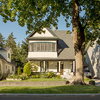
After the pandemic's initial shock made way for a strange new normal, Ellen Lou started to notice the subtle ways suburbia was changing.
Principal of the City Design Practice at the San Francisco office of Skidmore, Owings & Merrill (SOM), Lou found it wasn't necessarily about masks, outdoor dining at streeteries, or working from home. These transformations were more organic.
Neighborhood retail became more vibrant as stay-at-home office workers patronized local establishments. Walking and cycling grew more prevalent during lockdowns, spawning a national boom in bike purchases and outdoor activity. During the later months, local coffee shops and even coworking spots became crowded with workers who wanted to get out of the house but not return downtown.
"You could start to see the clues," says Lou. "What programs, and what changes, can make these suburbs work like this all the time?"
Lou's team of planners at SOM found an answer in the form of a new study: Suburban Reinvention. Its map of the Bay Area identifies areas where a strategy to build what they label "20-minute suburbs" — which eschew the standard single-family homes, exclusionary zoning, and centrality of the automobile for walkability, wellness, local commerce, and sustainability — could take root. Key are nearby transit stops and rail lines, as well as nodes in highway networks that provide a so-called "drive-to urbanism."
A riff off the ascendent 15-minute city idea, the concept recognizes that a quarter hour just isn't enough time to reach suburban retail and community amenities on foot or bike (and, frankly, many residents accustomed to car-centric living may be slow to adopt a half-hour round-trip walk to the store). "We say 20 minutes because that's where we need enough households to support the range of choices we like to have," Lou explains.
The concept argues that densification through a combination of zoning reform, transportation investment, and strategic commercial and residential expansion centered around existing transit could create more livable, walkable, and human-focused suburban neighborhoods, which could in turn promote greater housing affordability and sustainability.
Joo Cho, an associate principal at SOM and co-author of the study, says now could be the moment for such shifts. A renewed awareness of their surroundings has many suburban residents eager to see what a change in neighborhood character and design could mean, while increased urban-to-suburban migration offers an opportunity for more density — potentially with less pushback.

During the initial years of the pandemic, the Bay Area saw an uptick in residents moving from urban (gray) to suburban areas (orange). This pattern played out in cities across the country.

SOM's study reimagines much of the Bay Area as a series of 20-minute suburbs connected by transit to town centers, each other, and urban centers. Maps by Skidmore, Owings & Merrill.
Zoning reform and redesign
Despite these pandemic-driven changes, significant challenges to densification remain. One of the largest is selling residents on the power of such a transformation, particularly when it comes to traditional NIMBY pushback ("all these wealthy people don't want newcomers to come, and then they complain that housing prices are too high," says Lou).
But planning regulations and zoning reform, especially in the country's urban cores, have begun to chip away at the dominance of single-family homes. In many cases, these efforts are piloting the kind of policy toolbox suburban governments can use.
Minneapolis and many other cities have effectively banned single-family zoning, while California, arguably NIMBYism's birthplace and home to challenging-to-navigate environmental laws, has in recent years passed and imposed state-wide planning edicts and zoning reform. So far, that has included more bonuses for transit-oriented developments, legislation that allows vacated or unused commercial space to be transformed into housing, and a suite of laws to simplify the construction of accessory dwelling units (ADUs), which has led to over 60,000 new units permitted since 2016.
Ellen Dunham-Jones, a Georgia Tech professor, urban designer, and authority on sustainable suburban redevelopment, says it's also a national shift, with aging suburbs seeing surges of more permanent, structural changes over the past year. As she wrote for Monocle, "the pandemic exacerbated these communities' pre-pandemic struggles with a shortage of affordable housing, fear of gentrification, and glut of vacant retail property."
SOM's 20-minute suburb advocates for many of these changes, suggesting the addition of ADUs, missing middle housing like fourplexes, and some small multistory apartments at the apex of new commercial nodes to bring gentle density to sprawling landscapes.
Transportation reform, too
Importantly, increasing residential density should also come with transportation reform, says Cho, with paths, parkways, and bike lanes to make accessing retail sites easier and quicker. Last-mile transportation options and micromobility access are vital, too — but don't need to be costly or complex, she adds. Thoughtful additions of rapid bus service can often improve access without the cost of fixed transportation.
In a neighborhood of Boston called Mattapan — which can be compared to a denser suburb in terms of transportation usage, zoning, and residential building patterns — a long-term community planning process that started in 2018 has been engaging residents in co-creating a 10-minute neighborhood draft plan. The blueprint was released in October by the Boston Planning & Development Agency and envisions the neighborhood as a series of nodes and corridors, with an array of policy and design changes suburbia could leverage.
The 10-minute goal for Plan Mattapan grew in part out of the realization that even with most of the neighborhood within a 15-minute walk or transit trip to goods and services, car use and ownership remained widespread, says Jared Staley, an urban planner with the city leading the project. Ten minutes may be more ambitious, but the overlapping improvements in access and density made possible by that benchmark could be transformational.
One of the key aspects of the plan was increasing transportation access to cut down on car-usage and commute times (Mattapan residents have the longest commutes on average in the city). The plan calls for creation of more neighborhood hubs, better bike and bus networks, more trees and wider sidewalks, and a series of green pathways called Emerald Bracelets (a play off the Emerald Necklace, a chain of Olmsted-designed parks that encircle the Boston peninsula). These tiny, tree-lined walking paths with bioswales offer resilience, cooling, and recreation, plus help improve air quality in a neighborhood with a significant asthma rate. They also make traveling by foot more of an everyday reality.
This holistic effort is matched with zoning reform and commercial changes, including ADUs, and investment in public squares, public art, and ground-floor retail to revitalize local businesses and seed gathering spaces, all which reduce the need to leave Mattapan for basic goods and services. Staley envisions residents walking down Blue Hill Avenue and through Mattapan Square, past new trees and street furniture, to enjoy the hustle and bustle of their neighborhood with other residents.

The new model shows how suburban residents could be within 20 minutes of amenities and the town center via transit connections, bike paths, and pedestrian access. Illustration by Skidmore, Owings & Merrill.
Finding the right candidate
It's important when looking at these strategies to understand that not every place is the right candidate for commercial core revitalization and denser housing development, Dunham-Jones says. For instance, plans to turn a dying mall into a redeveloped town center — hundreds of which are currently in the works nationwide — should first grapple with why the shopping center didn't work in the first place. It might be a symbol of dwindling job prospects or a stagnant population.
One of the most famous success stories includes Lancaster, California, which transformed an existing commercial corridor along Lancaster Boulevard via streetscaping, carving lanes away from cars into pedestrian, adding bike lanes, and creating a linear gathering space in the center median. Finished in 2008, THE BLVD has long been seen as a catalyst for new stores and increased housing production nearby. Walkers Bend, Georgia, meanwhile, transformed a so-called "zombie suburb" into a vibrant mixed-income community by purchasing old lots and turning them into affordable and supportive housing for seniors. More recently, a proposal last year from urbanist Peter Calthorpe suggests transforming a series of strip malls on the 43-mile El Camino Strip in Silicon Valley into housing connected with autonomous shuttles.
Starting the process of neighborhood design and densification with a focus on commercial corridors can help overcome local pushback, says designer and urban planner Ben Bryant, AICP. In urban sections of Detroit lacking density, transit options, and sufficient amenities, his firm Interface Studio has helped measure the impacts of 20-minute neighborhood schemes via the Reimagining the Civic Commons project.
Public spaces — especially parks and gathering spaces that create activity and bring people back to the retail strip — provide a valuable sense of place and personality, can rally business owners and residents, and anchor other policy and development shifts, he says. In Fitzgerald, a neighborhood where Interface worked in Detroit, a local group purchased a vacant commercial storefront and created HomeBase, a space for meetings and events that provides access to city services. Community members also cleaned up a vacant lot and erected a small stage, a quick and cost-effective way to create a valuable performance and community space.
"There's an image in people's minds about what that place is all about," Bryant says. "It might be an iconic visual image. It doesn't even have to be a park. It has to be a place that's compelling, brings people together, and builds community."
Planners who focus on cities often overlook the "bones" of the suburbs, he adds, like the parking lot of an old gas station, or the large vacant space near a brewery. They show a different way of "taking what the suburbs already have" and rethinking how space is used to meet the needs of the future.
It's easy to center these kinds of neighborhood plans around housing. But while that can be critical to solving larger affordability, density, and transit challenges, it rarely presents the entire picture of a place, Bryant says — or engages residents with the most compelling narrative. The SOM study, for example, reckons with access and income differences across neighborhoods, proposing different focuses on amenities and community hubs depending on need. An emphasis on childcare and community centers versus neighborhood dining should be attuned to what residents value and want the most.
"If you're just focused on housing, you may not be touching on the immediate problems that people would like you to solve or focus on," Bryant advises. "You're trying to strengthen what people love about the place already, essentially."
RECOMMENDED ARTICLES