


Planning for Uncertainty With Climate Adaptation Pathways
By Melissa May, AICP, and Alice McLean, AICP, with David L. Revell, PhD, and Matthew Jamieson
KEY TAKEAWAYS
- Adaptation pathways help communities plan how to respond to the uncertainties of climate change over time by establishing a series of actions with associated triggers and thresholds, allowing them to monitor changing conditions and adjust their approach when those triggers or thresholds are reached.
- The adaptation pathways planning process can build community agreement around identifying goals, evaluating strategies and trade-offs, and knowing when it's time to change course, and is informed by technical analyses and climate science as well as local knowledge and lived experience.
- What this means for planners: Planners can use adaptation pathways as a flexible, practical planning approach to help their communities take action in the face of uncertainty, connecting long-term resilience goals with near-term decisions about land use, infrastructure, funding, and policy.
Increasing climate impacts, including sea level rise and extreme storm events, require flexible planning methods that address uncertainty and change. Photo by Jorge Corcuera/iStock/Getty Images Plus.
Contents
Adaptation Pathways 101
Case Study 1: A Pathways Approach for Coastal Roadways: West Cliff Drive, Santa Cruz, California
Creating Adaptation Pathways
Implementing Adaptation Pathways
Case Study 2: Adaptation Pathways in Practice: Hoaloha Park Adaptation Plan, Maui, Hawai‘i
Funding Considerations for Adaptation Pathways
Getting Started With Adaptation Pathways
Conclusion
Adaptation pathways offer planners a flexible framework for making long-term decisions about communities, development, and infrastructure amid uncertainty around future climate change and hazard impacts. Rather than focusing on a single forecast or fixed end-state, the pathways approach envisions a range of possible impacts and organizes adaptation actions into sequences that are implemented in response to observed impacts over time (Ferranti et al. 2021; Werners et al. 2021).
At the core of this approach is the idea that climate adaptation decisions should be linked to observable conditions. Key action points are defined by triggers (indicators of increasing impacts) and thresholds (tipping points of anticipated failure). Actions are implemented, adjusted, or replaced when changing conditions — such as increasing flood frequency, sea level rise, extreme heat, reduced infrastructure performance, or other measurable triggers — signal that an existing strategy is approaching a threshold or tipping point where it will no longer meet defined objectives.
Pathways enable communities to respond to near-term climate impacts while keeping sight of longer-term goals. They move beyond conventional “predict and plan” approaches by supporting threshold-based decision-making and flexible, phased investments over time. This allows decision-makers to phase strategies, preserve future options, and reduce the risk of investing too much too early in measures that may later prove ineffective or maladaptive. The pathways approach can also build stakeholder consensus, as it shifts the conversation from debating future uncertainties to agreeing on the observable conditions that would trigger future decisions and investments.
Adaptation pathways have been used in climate adaptation planning since the 2010s and are now widely advocated by academic and practitioner communities for navigating planning under deep uncertainty (Ferranti et al. 2021). Even so, they have not yet been broadly or consistently applied in planning practice. This is in part because many jurisdictions are not yet planning or budgeting consistently for climate adaptation. Additionally, pathway planning requires different types and levels of technical analysis than traditional land use and infrastructure plans, as well as a commitment to sustained monitoring for implementation. This creates a learning curve for agencies and requires committing both staff time and budget resources to support the scoping and technical analysis needed for adaptation plans. Despite these hurdles to widespread adoption, pathways are continuing to advance as a best practice, offering a practical and fiscally sound approach that connects long-range resilience goals to present-day choices.
This PAS Practical Guidance: Planning in Action makes a case for pathways as an effective long-term climate adaptation planning framework and provides action steps for planners to begin incorporating pathways in their work. It begins by providing background on the origins, applications, and benefits of the adaptation pathways approach and its relationship to climate adaptation planning and related planning processes. It then examines how adaptation pathways are developed, including common methodologies, key components, and the role of technical analysis and stakeholder engagement. It concludes with a discussion of implementation, including institutional, policy, and funding challenges; ways to integrate pathways into planning and agency frameworks; and action steps planners can take to begin applying this approach in their communities. Two case studies highlight recent applications of the adaptation pathways approach to address climate resiliency in coastal planning.
Adaptation Pathways 101
An adaptation pathway is a sequence of actions that are triggered by observable events and impacts over time to achieve defined objectives under changing conditions (May 2025). It is a flexible, decision-oriented approach that proactively selects strategies and actions to adapt to climate impacts amid uncertainty (Ferranti et al. 2021). Pathways use environmental indicators (thresholds, or tipping points when a strategy or condition is no longer tenable, and triggers, which indicate when it’s time to
shift to another strategy) to signal key decision points. Monitoring and direct observation, as well as evolving climate science, inform when to change strategies or adjust assumptions.
Pathways seek to avoid maladaptation by considering worst-case scenarios from the outset, identifying strategies that are effective under a range of possible futures, and enabling regular reviews to switch between strategies as needed. This approach favors low- and no-regrets actions, which are discovered through the process of developing pathways. Communication and discussion are key components; important outcomes include identifying a long-term vision and goals and vetting and prioritizing adaptation strategies with stakeholders.
Pathway development is based on an assessment of potential impacts and vulnerabilities informed by current climate science. This establishes a shared understanding of risks and potential impacts among project stakeholders and defines acceptable (or unacceptable) levels of risk and desirable (or undesirable) future outcomes. These inform the identification of goals and strategies for the pathway. Acceptable risk levels and desired outcomes will vary by stakeholder and may also change over time; for example, following an extreme weather event or disaster. Pathways can and should anticipate and incorporate strategies to respond to incremental impacts as well as episodic storm and disaster events, as the West Cliff Drive case study below highlights.
Pathways are typically implemented as part of a broader climate adaptation planning effort for existing development, ecosystems, or infrastructure, translating high-level goals and climate risk information into actions and investments amid uncertainty (Hamilton et al. 2025). Pathways provide the implementation logic within a larger adaptation planning structure; they help identify strategies to reduce risk and determine the most appropriate sequence of implementing actions in response to observable conditions over time.
Decision-Making Amid Uncertainty
Adaptation pathways have theoretical roots in applied research on decision-making amid changing or uncertain conditions, including decision-making under deep uncertainty (DMDU) frameworks. DMDU is a broader family of approaches developed for situations in which decision-makers cannot confidently predict future conditions, agree on probabilities, or fully define how systems will behave over time (Marchau et al. 2019; Walker et al. 2013; Weaver et al. 2013).
Adaptation pathways fit within the DMDU framework because they help planners make decisions even when future climate conditions, impacts, and stakeholder preferences remain uncertain. Rather than locking into a single projection or future scenario, as in a traditional “predict and plan” approach, both DMDU and pathways aim to take a holistic inventory of various alternatives, possible consequences, and conditions for implementation based on available information and use that to guide decision-making (Marchau et al. 2019).
Pathways take DMDU a step further by developing a menu of flexible and phased actions to respond to changing conditions, guided by continual monitoring and adjustment. They translate DMDU concepts into a practical framework that explicitly considers the sequencing and path dependency of decisions over time. Rather than asking, “What is the most likely future, and what single plan fits it?”, the pathways approach asks, “What actions work for now, under what conditions will they stop working, and what should happen next?”
The adaptation pathways approach has been in use since the mid-2010s. Academic-practitioner groups have described several variations (Ferranti et al. 2021), including dynamic adaptive policy pathways (DAPP) (Haasnoot et al. 2013; Kwadijk et al. 2010), dynamic adaptation planning (DAP) (Ranger et al. 2013; Wall et al. 2015), and adaptation pathways (Reeder and Ranger 2011; Rosenzweig et al. 2011).
Early Successes and Adoption
The adaptation pathway approach originated in Europe in the early 2010s, where it was first applied to flood risk management planning. Notable early projects include the Thames Estuary 2100 (TE2100) project in the U.K., a plan to manage tidal flood risk in the Thames Estuary (UK Environment Agency 2026), and the Netherlands’ Delta Programme, which addresses water management and climate resilience (The Netherlands 2026).
TE2100 was one of the first major infrastructure projects to explicitly address planning under deep uncertainty (Bloemen et al. 2017). The plan included route maps showing sequences of measures for several sea level rise scenarios through 2100. Uncertainties in sea level rise modeling at the time led practitioners to create a plan that considered multiple plausible futures. In the Netherlands, the adaptation pathways approach was first added to the 2011 Delta Programme. Planners sought to make climate adaptation planning less dependent on specific climate scenarios after improvements to scientific models necessitated across-the-board updates of existing climate adaptation plans (The Netherlands 2010; Haasnoot et al. 2024).
Both projects demonstrated that the adaptation pathways approach could keep decision processes moving forward despite uncertainty and evolving climate science, enabling decision-makers to take incremental steps toward adapting infrastructure (Bloemen et al. 2017). Governments in both jurisdictions successfully earmarked lands for future flood-defense structures and retention areas despite development pressures, as recommended by the long-term strategies identified within the plans.
Since those early successes, various municipalities throughout the world have used adaptation pathways for climate resilience planning and large infrastructure projects (Haasnoot et al. 2024). The adaptation pathways method is now considered a best practice for climate change adaptation planning.
Adaptation Pathways in U.S. Planning
While no comprehensive national framework guides the use of adaptation pathways in the United States, several federal agencies and states are applying this approach in guidance and plans.
In 2016, the Federal Highway Administration (FHWA) released a proposed Adaptation Decision-Making Assessment Process (ADAP) tool to help planners and designers “account for the increasing role of climate change in the design of civil works projects” (FHWA 2016). This guidance was later incorporated into several local efforts, including the West Cliff Drive adaptation project in Santa Cruz, California, described in the case study below.
More recently, in 2025, the U.S. Environmental Protection Agency (EPA) released a technical summary that provides a comprehensive overview of the concept and application of adaptation pathways for addressing climate change impacts (Hamilton et al. 2025). The summary offers guidance for planners and public officials.
California has formally incorporated adaptation pathways into its statewide sea level rise planning framework, primarily through the Ocean Protection Council’s Sea Level Rise Guidance (2024). State legislation has enabled funding mechanisms and collaboration frameworks for using this approach and requires some jurisdictions to create sea level rise plans (California Ocean Protection Council 2026). Additionally, the state’s Climate Adaptation Strategy (2024) and Adaptation Planning Guide (2020) include actions on adopting adaptation pathways for sea level rise planning.
The California Department of Transportation Updated Guidance on Incorporating Sea-Level Rise (2026) identifies adaptation pathways as a preferred approach for adapting existing transportation infrastructure, noting that “a combination of adaptation strategies may be necessary that clearly relate how short-, medium-, and long-term choices — or a ‘phased’ or ‘adaptation pathways’ approach — will collectively deliver long-term resiliency over time. For example, short-term protection through armoring may be used to maintain transportation services while a longer-term solution is planned or constructed that realigns the roadway” (Caltrans 2026, 3-16).
State guidance has informed local and regional adaptation plans incorporating pathways, such as the City of Santa Cruz’s West Cliff Drive Adaptation and Management Plan (2021; see the case study below), the Islais Creek Southeast Mobility Adaptation Strategy (2021) in San Francisco, the City of Carmel-by-the-Sea’s Local Coastal Program update (ongoing), and the Los Angeles County Metropolitan Transportation Authority’s Metro Climate Action and Adaptation Plan (2019). On a regional scale, the San Francisco Bay Conservation and Development Commission has advanced adaptation pathway development across the San Francisco Bay Area through its Adapting to Rising Tides program, Regional Shoreline Adaptation Plan (2024), and requirements for locally led subregional shoreline adaptation plans.
In Hawai‘i, multiple local and regional sea level rise adaptation plans incorporate a pathways approach. Among the first of these is the Hoaloha Park Adaptation Plan (2025), a site-scale plan for an urban beach park on Maui (see the case study below). Pathways are recommended for critical infrastructure adaptation planning in the City and County of Honolulu’s 2024 adaptation strategy (Climate Ready O‘ahu, Action 10.4) and in a proposed statewide framework for managed retreat (Hawai‘i OPSD 2026). Act 207 Relating to Regional Shoreline Mitigation Districts, a law passed in the 2026 state legislative session, establishes a statewide shoreline adaptation pathway planning framework. It calls for the creation of regional shoreline mitigation districts in which communities can work together to develop shoreline adaptation pathways plans.
On the other side of the country, New York City has begun using pathways in climate adaptation planning efforts. The city’s Climate Resiliency Design Guidelines (2022), mandated to take effect in 2027, incorporate this approach. Hurricane Sandy prompted a shift toward widespread transformation (Rosenzweig and Solecki 2014). This included significant investments in flood control projects, such as the East Side Coastal Resiliency Project and Lower Manhattan’s BIG U, both currently under construction (NYC 2025; Rebuild by Design 2025). And in Florida, the City of Miami Beach’s Sea Level Rise Adaptation Plan (2025) is organized into phased pathways based on changing conditions and decision points, and it provides expected lifespans for various flood-control strategies.
Applications and Benefits
Pathways are most useful for decisions or plans with the following characteristics (Haasnoot et al. 2024):
- Long-term lifespan or long societal impact
- Ongoing progression of impacts
- Consideration and integration of inherent uncertainties
- Path dependencies under which future options could be restricted due to earlier choices
This makes the approach particularly valuable for planners, who are well positioned to facilitate processes that establish a long-term future vision and identify policies and actions to support community well-being over time amid ongoing changes, including climate change impacts.
Adaptation pathways can be applied across scales ranging from individual facilities or sites to entire infrastructure systems, neighborhoods, or cities. They have been developed for sectors from infrastructure (Ferranti et al. 2021) to irrigation (Nikkels et al. 2019), food production (Coulter 2019; Tanaka et al. 2015), forest management (Kaczorowski 2026; Millar et al. 2007), and habitat conservation (Jacobs et al. 2019). Similarly, they can be used for multiple types of climate impacts, from flooding and sea level rise (Barnett et al. 2014; Bloemen et al. 2017; Wall et al. 2025) to drought (California Department of Water Resources 2025), wildfire (Paveglio et al. 2024), and heat (Kingsborough et al. 2017).
Finally, adaptation pathways planning applies to existing assets. New development or infrastructure proposals should factor future climate impacts into siting and design decisions from the outset.
CASE STUDY 1
A Pathways Approach for Coastal Hazards: West Cliff Drive, Santa Cruz, California
In Santa Cruz, California, the West Cliff Drive Adaptation and Management Plan (2021) considered long-term exposure of this multimodal transportation corridor as well as public trust coastal resources to coastal hazards and sea level rise. Planners used the pathways approach, working with stakeholders to envision long-term impacts and identify and evaluate a sequence of phased public works projects that could be implemented over the next 10 to 15 years based on observed triggers and thresholds.
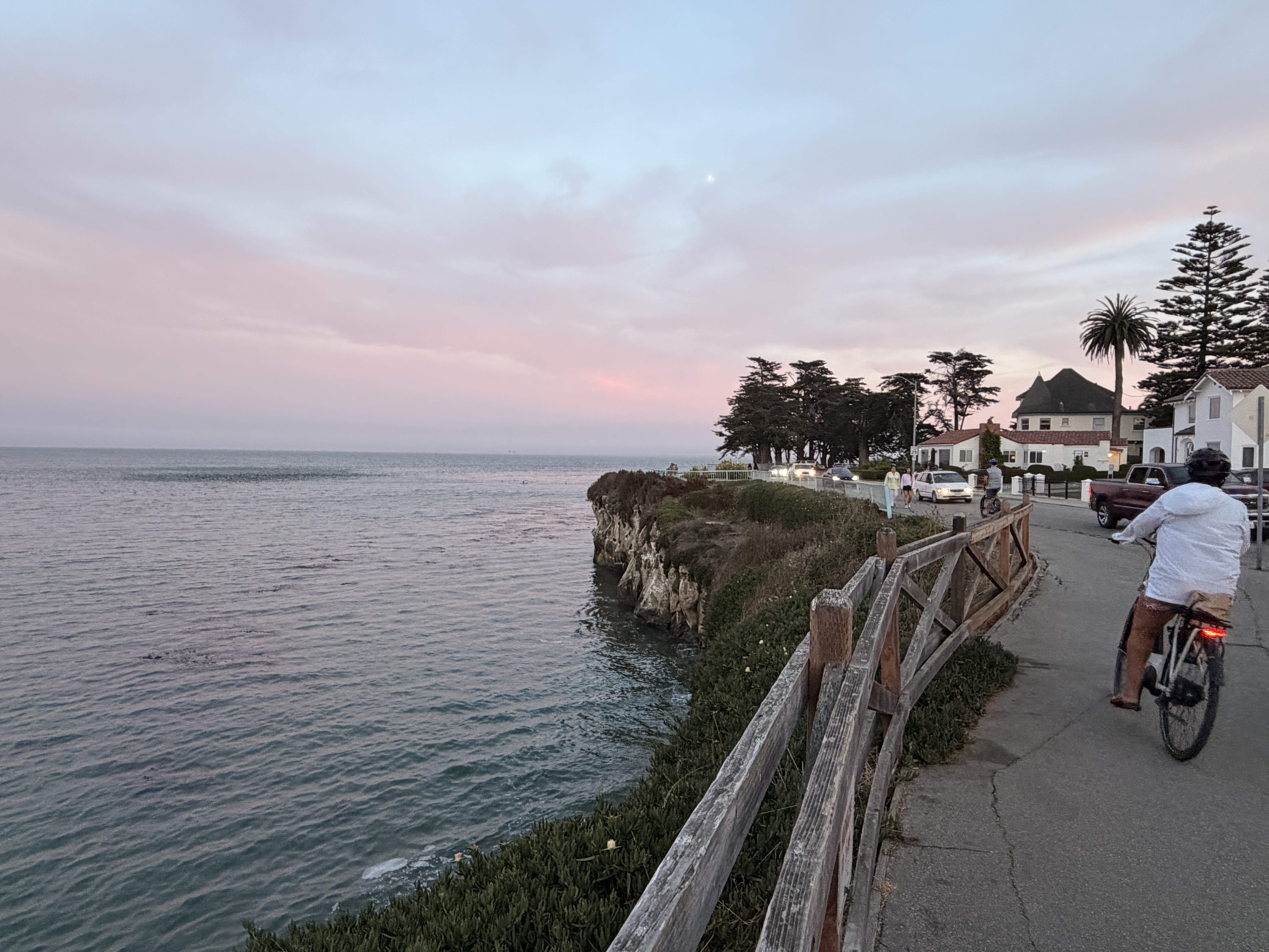
Figure CS1.1. West Cliff Drive is a multimodal transportation corridor in Santa Cruz, California (photo courtesy Melissa May)
West Cliff Drive runs along a coastal bluff that is vulnerable to erosion, sea level rise, and storm surges (Figure CS1.1). The planning process created adaptation pathways for four segments of West Cliff Drive. They reflect stakeholder input gathered through focus groups, community and one-on-one meetings, public surveys, and a technical advisory committee, as well as technical studies including climate hazard modeling, engineering analysis, social vulnerability assessment, and cost-benefit analysis.
The adaptation projects and strategies identified in the plan support community-identified objectives of protecting and enhancing coastal resources, including recreation, access, transportation, parking, habitat, facilities, open space, amenities, and utilities. The plan specifies quantifiable triggers for each segment and outlines monitoring and maintenance procedures to reduce the need for emergency responses. Table CS1.1 provides examples of triggers used across the four roadway segments.
Table CS1.1. Examples of Adaptation Pathway Triggers
| Timeframe | Trigger |
|---|---|
| Short-term | Disruptions to traffic or recreational trail X times per year |
| Mid-term | Cliff erosion within X feet of recreational trail Beach width narrows to less than X feet |
| Long-term | City spends more than $XXX,XXX in repairs over five years |
The pathways approach allowed planners to effectively engage much of the community and develop sequenced phasing based on observable changes rather than a specified timeframe or sea level rise elevation. This incremental, flexible approach garnered broader community acceptance and demonstrated more ecological and recreational co-benefits than a traditional “one and done” shoreline engineering approach. The plan identified near-term projects for monitoring, maintenance, and targeted repairs, while preserving the ability to shift to mid- and longer-term strategies — including eventual managed retreat — as triggers are reached (Figure CS1.2).
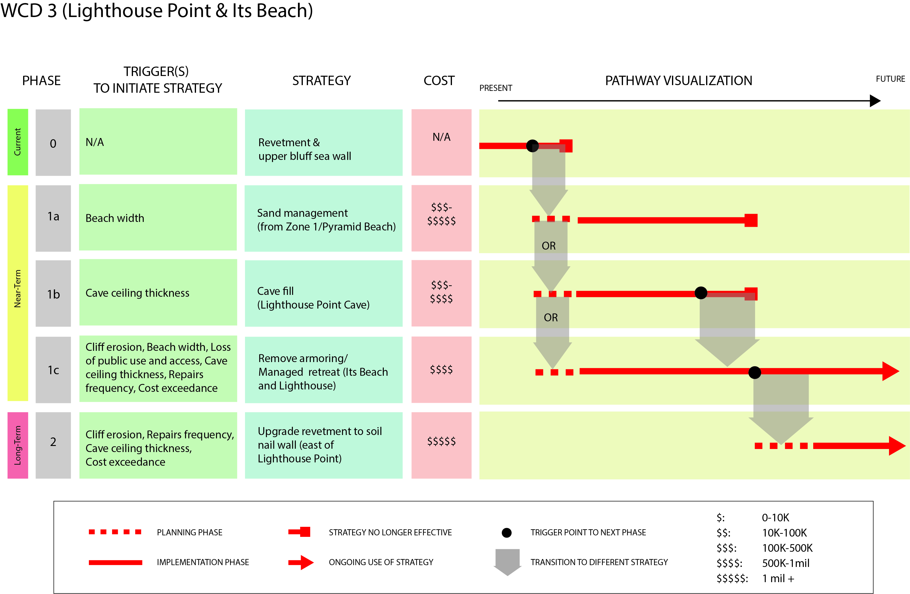
Figure CS1.2. West Cliff Drive adaptation pathways establish current, mid-term, and long-term strategies to address coastal erosion (courtesy Sarah Stoner-Duncan, Matthew Jamieson, and David Revell)
Unfortunately, the best-made plans can be overridden by unforeseen challenges. In 2023, a major storm event known as a bomb cyclone caused devastating erosion along West Cliff Drive across multiple locations identified in the plan (Figure CS1.3). The extensive community impacts exceeded most of the triggers identified in the plan and met the threshold for a federally declared disaster, qualifying the city for recovery funding from the Federal Emergency Management Agency (FEMA). The triggers and pathways in the plan had not yet been codified into local land use plans and the city’s Local Coastal Program, however, and FEMA disaster recovery funds typically require structures to be rebuilt in the same location. With community emotions running high and strong political pressure to pursue recovery and rebuilding, the city could not implement the pathway as designed.
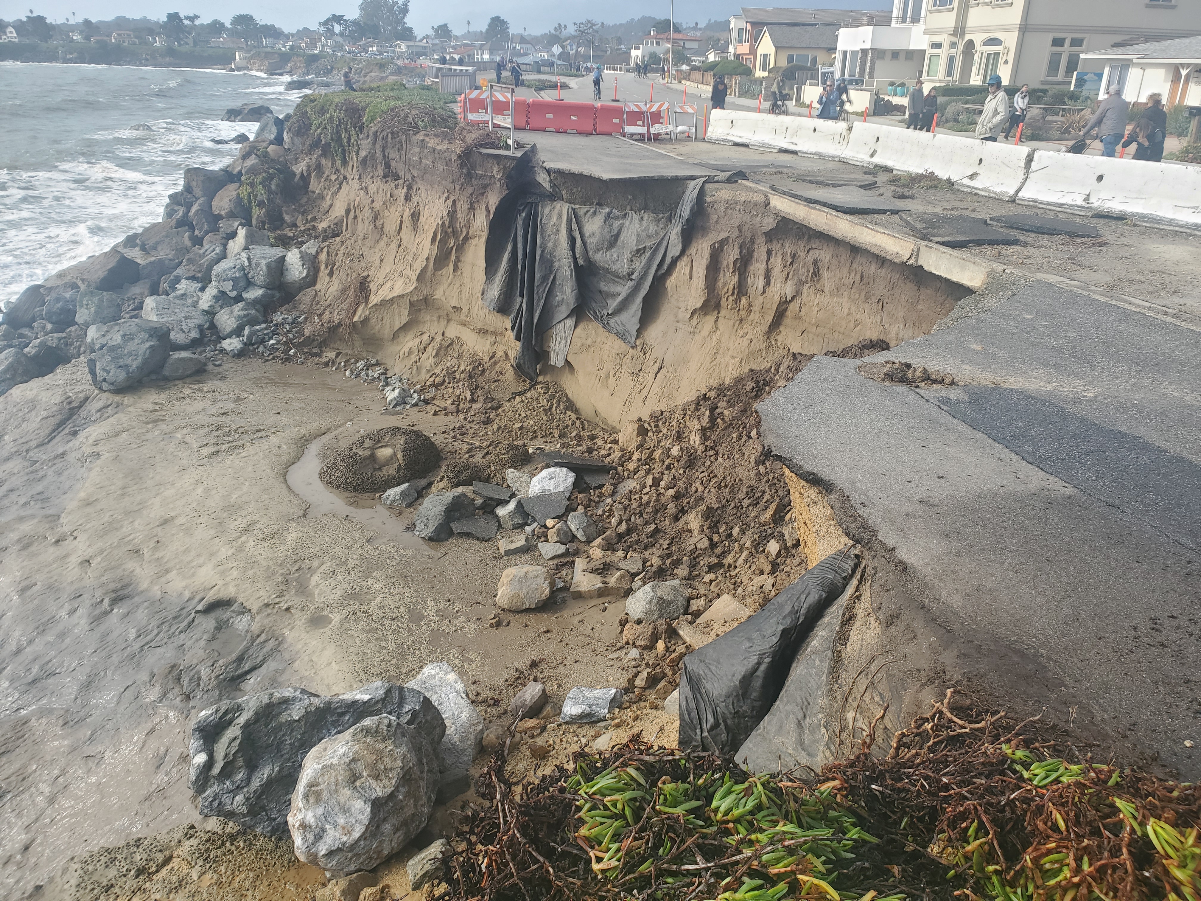
Figure CS1.3. 2023 bomb cyclone impacts to West Cliff Drive (photo courtesy David Revell)
This unforeseen outcome highlights the importance of considering unexpected or episodic events, such as a federally declared disaster, in pathway development. Post-disaster recovery and rebuilding is an opportunity to reenvision and reconstruct damaged portions of the community to support long-term resilience. Overcoming the intense emotions and political pressures in a disaster’s aftermath is difficult. It requires a preconceived vision and plan with community buy-in, codified within local planning documents and hazard mitigation plans.
Adaptation pathways that address a disaster scenario could redirect FEMA disaster recovery funds toward a new vision rather than a simple rebuild. While pathways cannot realistically anticipate every possible disaster and impact scenario, they can incorporate triggers and thresholds that address an extreme event and provide strategies to guide recovery in alignment with long-term community vision and adaptation goals.
Following the storm recovery effort, the City of Santa Cruz has continued to engage the community in visioning and refining adaptation pathways and integrating them into key planning documents, including the 2025–2030 Local Hazard Mitigation Plan and the 2025 update of the Local Coastal Plan's Beaches and Bluffs chapter.
This case study was authored by David L. Revell, PhD, Integral Consulting.
Creating Adaptation Pathways
While pathways share common components, the methods used to develop them vary depending on planning context, decision-making scales, uncertainty levels, data availability, and stakeholders’ roles in shaping outcomes.
Pathway Components
Adaptation pathways are built from a set of linked components that help planners make decisions over time under changing conditions (May 2025):
Goals define the long-term vision for a place, asset, or system—such as maintaining public safety, preserving service, or protecting community character—and describe future desired conditions based on a shared understanding of risks and vulnerabilities grounded in climate science and place-specific impact assessments.
Criteria establish acceptable levels of risk or disruption that align with the defined goals and vision. They may incorporate parameters such as performance requirements, service levels, downtime, damages, or design life to define critical triggers and thresholds for action.
Adaptation strategies identify actions that will help communities meet goals as conditions change. Actions are typically prioritized based on feasibility, cost, regulatory viability, effectiveness, and community acceptance, along with potential co-benefits and consequences.
Triggers are observable changes in conditions that signal when an identified threshold of unacceptable impacts is approaching and it is time to shift to the next action on the pathway. Triggers and thresholds are based on the criteria defined above. Table 1 provides examples of triggers and thresholds for different asset types.
These components come together to create a pathway, which shows the phasing and sequencing of strategies over time (Figure 1). Actions are linked to triggers based on the established criteria, rather than fixed dates. By providing a decision-oriented sequence of actions linked to triggers, thresholds, lead times, and monitoring needs, pathways provide a clear implementation roadmap grounded in scientific and technical study, community vision, and a clear understanding of costs, benefits, and trade-offs.
Table 1. Example Triggers and Thresholds for Local Assets
| Asset Type | Example Triggers | Example Thresholds |
|---|---|---|
| Roads | The number of flooding events doubles over X years | The road is closed more than X days per year |
| Parks | Seasonal beach loss exceeds X feet | Park users cannot safely walk along the shoreline |
| Water systems | Saltwater intrusion is detected | Drinking water standards are exceeded |
| Storm drains | Outlet is fully submerged at king tides | Drainage backup and ponding occurs X times or more per month |
| Neighborhoods | Repetitive loss claims reach a designated limit | Recovery costs exceed the acceptable maximum |
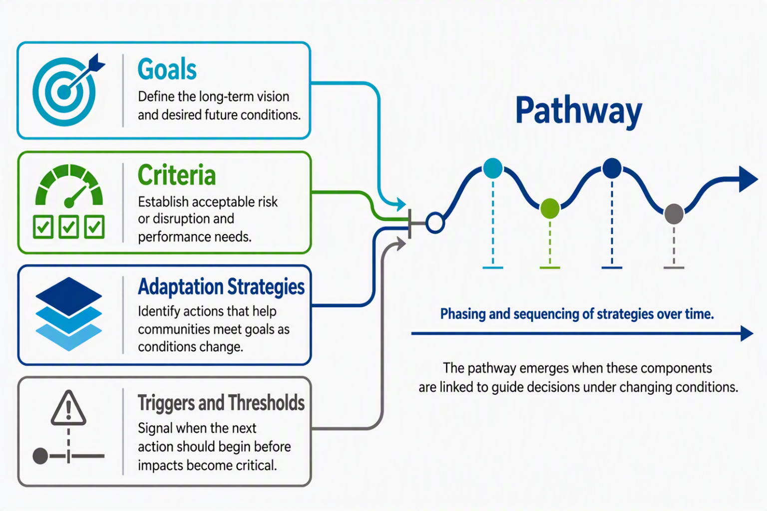
Figure 1. Typical components of adaptation pathways include goals, criteria, adaptation strategies, and triggers and thresholds (courtesy Melissa May)
When comparing adaptation strategies and building pathways, planners should consider costs, trade-offs, and co-benefits. Costs include implementation and maintenance, while benefits may encompass avoided damages, environmental and social effects, public safety, ecosystem benefits, and economic efficiency. In Santa Cruz, for example, an economic valuation study of surfing found that this single recreational use generates approximately $200M annually for the local economy (Anning et al. 2025). It also considered the effect of different adaptation strategies on surfability and showed how certain adaptation strategies could reduce or maintain that economic driver.
Monitoring both implementation plan progress and changing conditions is essential. Monitoring plan progress ensures that implementation steps and investments remain on track. Monitoring changes to observable conditions tracks the agreed-upon triggers and thresholds over time and provides the basis for determining when to switch to another predetermined strategy or pathway.
Depicting adaptation pathways graphically through diagrams and visualizations helps communicate the pathway clearly to diverse stakeholders. Common visualization types include metro maps, decision trees, bar plots, timelines, and solution spaces (Figure 2) (Haasnoot et al. 2024). Metro maps, named for their resemblance to a subway map, are often used as they can be organized by thresholds and signals; reasons and futures; or short-, medium-, and long-term time horizons.
Besides depicting phased adaptation strategies, sharing adaptation pathway visualizations in stakeholder engagement activities helps communicate concepts and build stakeholder support (Bloemen et al. 2017).
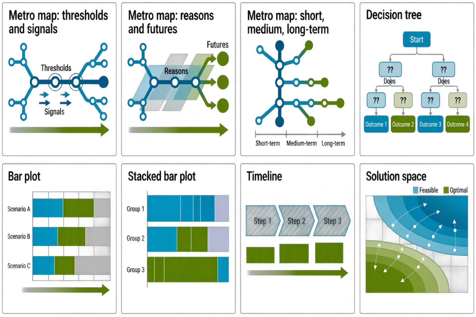
Figure 2. Types of visualizations used for adaptation pathways (adapted from Haasnoot et al. 2024, CC BY 4.0)
Pathway Development
Adaptation pathways should reflect a project’s unique context, goals, and decision-making environment. The process for developing and implementing adaptation pathways can be broken down into seven steps (Werners et al. 2021):
- Assess the decision context and develop goals and criteria.
- Assess vulnerabilities and opportunities.
- Identify, analyze, and prioritize adaptation actions.
- Develop and evaluate pathways, considering trade-offs between damages to existing development, infrastructure, and resources.
- Codify pathways and triggers into plans and budgets accordingly.
- Implement pathway actions.
- Monitor outcomes to determine when predetermined triggers or thresholds are reached.
The adaptation pathway process is flexible and should be tailored to the project context. Based on the degree of uncertainty, consensus, and other factors, planners may identify one preferred pathway or create multiple alternative pathways.
The stepwise approach of pathways can help overcome action paralysis that can arise from the uncertainties of future climate impacts. This approach can also make planning processes more transparent as triggers, thresholds, and phasing of the adaptation pathways are agreed on in advance and codified into planning documents.
For some projects, adaptation needs may be well understood, data and expertise are readily available, goals can be easily identified and agreed upon, and implementation is within the purview of one or a few decision-makers. This may be the case when preparing a pathway for a discrete facility or system that is owned and managed by a single agency or entity. More often, however, planning contexts encompass multiple stakeholder groups with diverse and sometimes conflicting goals, interests, and values. In these cases, planners should focus on promoting collaborative learning and knowledge-sharing, working toward consensus, and building the adaptive capacity of agencies and communities (Werners et al. 2021). Where stakeholders desire transformational community change, pathway development can start with a future vision and work backwards to identify the actions needed (Werners et al. 2021). This may be appropriate for communities facing unavoidable impacts or communities seeking to build resilience when recovering from a disaster.
Common Pathway Inputs
Adaptation pathways can be developed using both quantitative and qualitative inputs (Werners et al. 2021). These are described in Table 2.
Table 2. Common Inputs for Adaptation Pathway Planning
| Input Type | Description | Use |
|---|---|---|
| Historical and environmental data | Documents and datasets showing how natural and built environments have changed over time, including shoreline change, flooding, erosion, land use, habitat conditions, watershed processes, and ecosystem health | Provides context for long-term environmental trends, identifies climate-related changes, and helps evaluate how adaptation strategies may affect natural resources and ecosystem functions while setting expectations for future change |
| Social equity and demographic data | Information identifying populations that may be disproportionately affected by climate hazards or adaptation actions, including vulnerable populations, service-dependent communities, and areas with existing social or economic inequities | Supports equitable prioritization, stakeholder engagement, and evaluation of adaptation strategies and tradeoffs |
| Place-based and traditional ecological knowledge | Lived experience, practitioner expertise, Indigenous knowledge, and community input gathered through engagement and research | Provides insights into historical conditions, environmental change, community values, and locally observed impacts not captured by technical datasets |
| Asset, infrastructure, and system information | Asset inventories, ownership and operational records, maintenance histories, interdependencies, performance requirements, and criticality assessments | Identifies risks, system functions, and the consequences of disruption or failure |
| Climate science, hazard data, and future projections | Data describing current and future climate stressors and hazards, including sea level rise, flooding, erosion, heat, drought, storms, and compound events, often provided as spatial datasets | Supports analysis of future hazards, exposure, and vulnerabilities by overlaying projected hazards with existing communities, infrastructure, and natural resources |
| Hazard exposure, vulnerability, and risk assessments | Screening-level analyses to detailed site-specific modeling of how hazards interact with assets, infrastructure, ecosystems, and communities, considering exposure, sensitivity, adaptive capacity, consequences, and priority risks | Identifies key vulnerabilities and risks, prioritizes areas for action, and informs adaptation strategy development and sequencing. |
| Technical and scientific analyses | Studies of physical processes such as geomorphology, hydrology, sediment transport, and groundwater dynamics, including modeling of future conditions under different scenarios | Improves understanding of site-specific processes and informs adaptation strategies that respond to local environmental conditions |
| Engineering and implementation studies | Technical assessments evaluating the feasibility, performance, constructability, operational requirements, lead times, and planning-level costs of adaptation strategies | Helps determine strategy feasibility and provides information on implementation costs, benefits, and constraints |
| Legal, planning, and policy analyses | Reviews of laws, regulations, plans, permitting requirements, land ownership, and governance frameworks that may influence adaptation | Identifies legal and institutional barriers, implementation opportunities, and policy changes needed to support long-term adaptation and strategy prioritization |
| Economic and financial analysis | Assessments of costs, benefits, avoided damages, lifecycle implications, funding opportunities, and broader social, environmental, recreational, and economic trade-offs associated with adaptation strategies | Evaluates the economic performance of adaptation options, incorporates social and environmental values where possible, and informs investment decisions and funding strategies |
| Prioritization and decision-support frameworks | Tools such as scorecards, multicriteria analyses, and screening methods that compare adaptation options using criteria such as effectiveness, flexibility, equity, environmental performance, feasibility, and implementation constraints | Supports transparent evaluation and prioritization of adaptation strategies and ensures selected pathways align with stakeholder values and project goals |
Some of the inputs described in Table 2 are needed to begin developing adaptation pathways, while others can help inform pathway vetting and refinement later in the process. The data required will vary based on the type of asset and defined adaptation goals. At a minimum, pathways planning requires sufficient information to understand potential vulnerabilities and economic impacts, define adaptation goals, identify thresholds or conditions that would trigger action, and develop a preliminary set of adaptation strategies.
Engineering studies, economic analyses, site-specific hazard modeling, and comprehensive vulnerability assessments can greatly improve the quality and defensibility of pathways but are not always necessary to begin the process. For communities with limited data, technical capacity, or funding, an initial pathways framework can often be developed using a combination of publicly available datasets, local and traditional knowledge, qualitative thresholds based on lived stakeholder experience and observations, and simple monitoring indicators, with more detailed studies identified as enabling actions within the pathway.
As one example of a project that did not rely on detailed technical studies, the township of Lakes Entrance in Victoria, Australia, used stakeholder engagement and publicly available data as a starting point to create conceptual adaptation pathways (Barnett et al. 2014). The planning process gathered community input based on lived experience to identify locally relevant triggers and thresholds, define foundational community values, determine socially acceptable levels of risk, and identify potential adaptation strategies. This engagement-centered approach provided a strong foundation for goal-setting and vetted adaptation strategies for community acceptance, both of which are important inputs to adaptation pathway development and can precede more costly technical analyses.
In contrast, the Hoaloha Park Adaptation Plan (2025) in Maui, Hawai‘i (see case study below) is an example of a more technically intensive pathway development approach. It combined publicly available county-level data with site-specific studies characterizing site conditions, park usage patterns, infrastructure, traffic and circulation, hazard vulnerabilities, and cultural and historic resources.
Stakeholder Engagement
Engaging local stakeholders in pathways development as early and often as possible has multiple benefits (Haasnoot et al. 2024; Lawrence and Haasnoot 2017):
- Incorporating a diversity of values and objectives into the adaptation vision and plan.
- Enhancing understanding of complex systems through the integration of community knowledge.
- Identifying a wider range of potential options and strategies for pathway development.
- Flagging implausible options or strategies early in the process.
- Vetting strategies and triggers to ensure they are not just technically feasible, but also socially acceptable and compatible with institutional processes and frameworks.
- Helping to build trust and confidence in decision-making processes.
- Increasing buy-in for the final plan.
Limiting stakeholder engagement can likewise limit the identification of pathway options. This can lead to undesirable outcomes or adherence to the status quo when transformative change may be needed (Lin et al. 2017). Involving affected communities and other stakeholders in decision-making supports more equitable infrastructure investments. Plans should address the needs of underinvested and overburdened communities by incorporating quality-of-life considerations, social impacts, and environmental health into the criteria for selecting adaptation strategies.
In addition, building capacity for climate adaptation is critically important within the organizations and agencies responsible for local facilities and infrastructure. Planners can meaningfully engage infrastructure managers and planners in designing feasible, actionable adaptation pathways while building staff capacity and knowledge. This can shift decision-makers from a reactive, day-to-day focus on operational concerns to a longer-term perspective on adaptation needs for assets at risk.
Community involvement can extend beyond planning to design, monitoring, and implementation of adaptation pathways. Community champions and volunteers can take part in efforts such as planting and maintenance for dune restoration and living shorelines in coastal areas, and citizen science initiatives can help document changing conditions and impacts to inform monitoring of triggers and thresholds.
Implementing Adaptation Pathways
Though the urgency to plan for adaptation is increasing and pathways are a recognized approach to helping communities act under uncertainty, agencies have been slow to adopt this approach. Many jurisdictions lack familiarity with pathways and do not have adaptation planning frameworks for developing them; agencies may not have the staff capacity or data needed to maintain a pathways approach; and political and funding systems often favor short-term, discrete projects over phased, adaptive action and ongoing monitoring.
These barriers are not insurmountable. Planners can help agencies build capacity and support for pathway development by linking long-term climate impacts to near-term decisions, establishing a clear process for agencies to follow, formalizing roles and coordination processes across departments, aligning implementation and monitoring with existing processes and practices, and showing how a phased approach to adaptation can reduce long-term costs, avoid maladaptation, and preserve future options.
Understanding the Challenges
Barriers to using adaptation pathways approaches may be policy-related, technical, institutional, or financial. Understanding the different challenges that may arise can help planners determine proactive solutions.
Policy and governance barriers. The use of adaptation pathways depends on supportive policies, funding availability, institutional support, and legislation or political will. These factors may be weak or absent due to competing policy priorities, lack of awareness and education, and ideological or political differences. In the U.S., a lack of familiarity with adaptation planning frameworks compounds this challenge.
Technical and data challenges. Pathways require baseline data on climate hazards, vulnerabilities, asset conditions, and projected impacts to identify where risks may emerge and when strategies may lose effectiveness. Monitoring data is also needed to track triggers and thresholds over time. These data sources may be incomplete, inconsistent, or unavailable at the scale needed for decision-making (Haasnoot et al. 2024; Bloemen et al. 2018).
Pathways also frequently incorporate technical inputs, including site-specific hazard modeling, geomorphological studies, engineering feasibility analyses, economic evaluations, infrastructure performance criteria, and data collection and monitoring protocols. These require technical expertise and additional resources.
Institutional and implementation barriers. Even where interest in pathways exists, agencies may lack the training, staffing, and internal guidance needed to use them effectively. Monitoring requires long-term coordination, clear roles, and ongoing capacity to collect and interpret data and feed it back into planning and decision-making. Because pathways often cut across multiple agency functions, they demand unusually strong coordination among planning, engineering, finance, operations, hazard mitigation, and community engagement staff.
Implementation can be further slowed by uncertainty around roles, responsibilities, and legal liability, especially when long-term risk, major capital decisions, or changing service levels are involved (Lin et al. 2017). More broadly, pathways can be difficult to integrate into infrastructure systems and bureaucratic processes designed around fixed standards, discrete projects, and static funding cycles.
Funding limitations. Funding is a persistent barrier, as adaptation pathways require initial and ongoing investments in planning, analysis, engagement, and monitoring to support phased implementation. Up-front costs may include hazard and vulnerability analyses, engineering and economic evaluation of strategies, stakeholder engagement, and development of monitoring protocols and systems. Longer-term costs include periodic updates, ongoing monitoring and data collection, and implementation of phased actions as triggers are reached. Capital improvement programs typically prioritize short-term needs and discrete projects, making it harder to fund flexible, staged adaptation approaches.
Institutionalizing Pathways
Planners can play key roles in developing pathway frameworks and working with agencies to institutionalize them. One example is the City and County of Honolulu Office of Climate Change, Sustainability, and Resiliency‘s Adaptation Pathways for Critical Infrastructure project. A planning team, which includes the authors, is helping City and County infrastructure agencies develop an adaptation pathway methodology for four asset types: roadways, parks, maintenance facilities, and drainage infrastructure. The project encompasses a technical working group, multi-agency workshops, training, templates, and a detailed manual to support continued adoption and institutionalization of adaptation pathways within those agencies.
Institutionalizing adaptation pathways involves embedding them into plans, decision-making processes, and capital investment frameworks. It may require a paradigm shift from reactive, short-term thinking and processes to long-term, risk-based decision-making informed by technical study and economic analysis. Institutionalization also requires breaking down agency siloes for greater coordination across land use, infrastructure, hazard mitigation, capital planning, asset management, and community engagement.
Build the case for long-term planning. Infrastructure agencies may lack internal frameworks and processes for long-term planning and budgeting, and long-term planning functions may not consider climate change impacts. Institutionalizing pathways in these contexts could require changes to agency mandates, staffing, and funding to support long-term climate risk–informed planning.
Planners can start by helping agencies understand the long-term risks facing their facilities and the potential consequences of not factoring those risks into short-term decisions. Many agencies already face climate change impacts to infrastructure and can understand the merits of acting proactively to protect or adapt rather than responding after a failure. Working through specific scenarios or examples and comparing the costs and trade-offs of different approaches, including the cost of inaction, creates a compelling case for pathways as a framework for making informed decisions and investments.
Develop coordination frameworks. Adaptation pathway planning requires looking beyond the facility, infrastructure system, or neighborhood to identify the systems and services that it depends on, adjacent uses, and the needs of the people it serves. Planners developing pathways need to consult with stakeholders responsible for adjacent or interdependent infrastructure, understand how they are planning for future climate adaptation, and factor that information into the pathway.
Developing a framework for interagency coordination can save time, align project planning and priorities, and leverage limited funding through coordinated investments and data sharing. Agency coordination can also support sharing or delegation of responsibilities for vulnerability assessments, stakeholder engagement, and monitoring.
One example of a coordination framework is the “One Water” approach used by infrastructure agencies to coordinate their efforts around water resources management and climate resilience (Cesanek et al. 2017). The City and County of Honolulu’s One Water Honolulu program encompasses a One Water ordinance, an interagency One Water Panel that coordinates climate-adaptive infrastructure improvements, and a One Water plan. Other municipalities that practice One Water include San Francisco, with the San Francisco Public Utilities Commission’s OneWater SF program; Denver, with the Denver One Water Program; Portland, Oregon’s One Water initiative; and Fort Collins, Colorado, with its One Water Action Framework (2025).
Establish requirements and guidance for pathway development. Policies and rulemaking at the legislative or agency level can establish requirements and guidance for adaptation pathways. Enabling legislation or agency charters can require integration of pathways into existing plans and processes, assign responsibility for pathway development, and describe required elements or processes.
For example, the San Francisco Bay Conservation and Development Commission (BCDC) Regional Shoreline Adaptation Plan (RSAP) (2024) requires pathway development as an element of sub-regional adaptation plans that all local governments within BCDC’s jurisdiction must prepare by January 1, 2034. It describes the process for developing pathways along with required deliverables and standards for evaluating adaptation strategies and integrating equity. BCDC also offers free training on RSAP requirements to agencies and practitioners.
Clear guidance helps overcome barriers to institutionalization and ensures consistent application. Pathway development guidance can specify details such as which climate scenarios and sea level rise planning benchmarks to use, which data sources to consult, how to incorporate equity considerations and stakeholder engagement into pathway development, how to identify relevant triggers and thresholds, and standards or criteria for adaptation strategy selection and prioritization.
Guidance should be flexible enough to apply to a wide range of assets and contexts and allow for alternative approaches where data or funding is lacking or other constraints exist. As noted above, FHWA and the State of California have issued guidance for using pathways-based approaches at the local level.
Integrate pathways into planning frameworks. Integrating pathway approaches into existing planning frameworks is a critical step. Typically, pathways are developed as part of a climate adaptation plan for an asset, facility, infrastructure system, neighborhood, ecosystem, or community. Comprehensive plans, infrastructure and utility plans, hazard mitigation plans, capital improvement programs, resilience plans, vulnerability assessments, management plans, and agency procedures can also incorporate pathway development or contribute helpful inputs. These documents identify community priorities and vulnerabilities, planned investments, regulatory constraints, service standards, and existing policy commitments. These are all important ingredients for setting goals, establishing criteria, identifying triggers and thresholds, and prioritizing and sequencing pathway actions.
Once pathways are developed and finalized as part of a planning effort, they should be referenced in and incorporated into future updates of related plans (e.g., comprehensive land use plans, functional plans, hazard mitigation plans, disaster recovery plans, master plans, facility plans), capital programming, design codes and standards, operational procedures, and monitoring systems.
Link pathways to budgeting and capital planning. Planners can facilitate pathway implementation beyond the planning phase by tying pathway recommendations to budgeting and capital improvement program processes. This requires translating adaptation strategies identified in pathways into phased capital investments.
Phasing should incorporate lead time needed for planning, design, permitting, financing, and construction, so that action can begin before unacceptable impact thresholds or tipping points occur, as well as time to decommission or retire previous structural interventions (Figure 3). Planners can also strengthen the case for funding pathway implementation by showing how phasing investments may reduce long-term costs, avoid maladaptive approaches, and preserve flexibility under uncertain conditions.
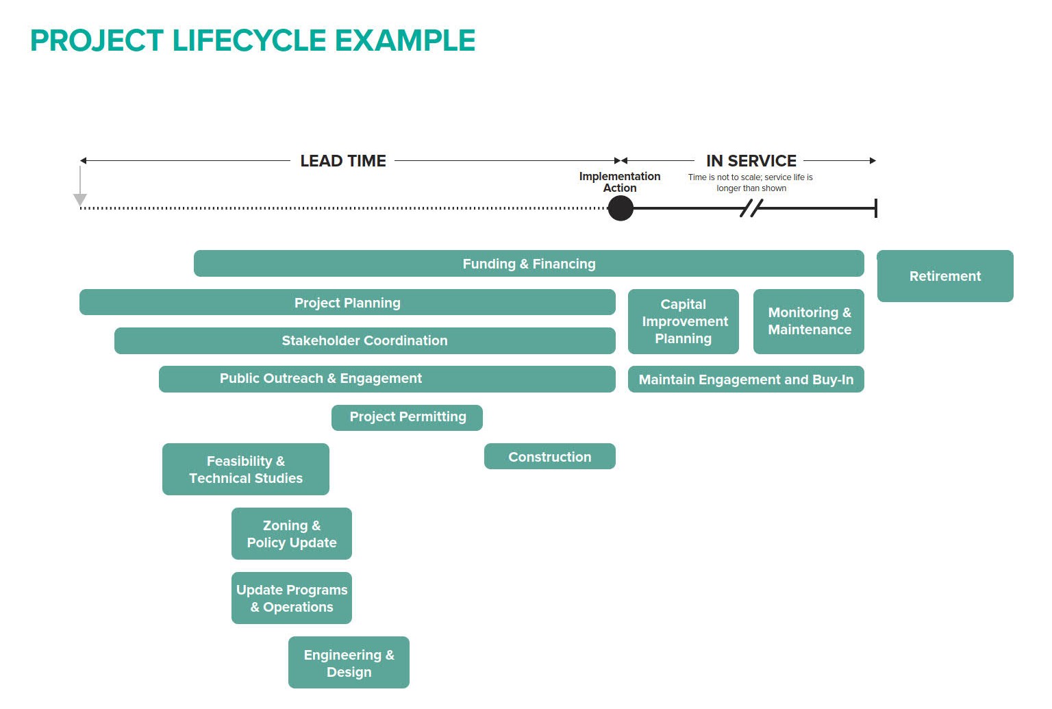
Figure 3. Phasing of adaptation pathway implementation actions must incorporate adequate lead time for project planning and construction (courtesy Matthew Jamieson and Graham Nash)
Streamline pathway implementation and monitoring. Planners should align pathway implementation frameworks with existing agency processes, data sources, and procedures. When defining pathway triggers and thresholds for long-term monitoring, planners should identify and leverage data already being collected through inspections, maintenance activities, condition assessments, hazard tracking, post-storm reviews, and other routine reporting systems, rather than creating new data collection responsibilities or investing in new monitoring technologies.
Integrating partners into pathway development can lessen the administrative burden on agencies while building community capacity and awareness around resilience. Universities, nonprofit organizations, and community groups can be valuable partners in data sourcing, collection, analysis, and monitoring. Citizen science can supplement agency data, leveraging community networks and place-specific knowledge to track changing conditions and emerging impacts. For example, the California King Tides Project and the Hawai‘i and the Pacific Islands King Tides Project encourage community members to upload their photos of the highest predicted natural tides of the year to interactive maps. Scientists, planners, and the public can use these photos to monitor changing conditions and visualize possible future sea level rise impacts.
Pathway implementation frameworks should clearly identify responsible parties and timelines for monitoring, reporting, budgeting, and performance evaluation over time, and create procedures for revisiting pathways when thresholds are approached or reached. Incorporating implementation needs into agency operations and procedures is a key component of institutionalizing the pathways approach.
CASE STUDY 2
Adaptation Pathways in Practice: Hoaloha Park Adaptation Plan, Maui, Hawai‘i
The Hoaloha Park Adaptation Plan, completed by the County of Maui Department of Parks and Recreation (DPR) in 2025, is the first adaptation plan developed for a Maui County beach park (Figure CS2.1). This case study demonstrates how adaptation pathways can be applied to a site-scale adaptation planning effort. Elements of the seven-step pathway development process described in this article are highlighted throughout.
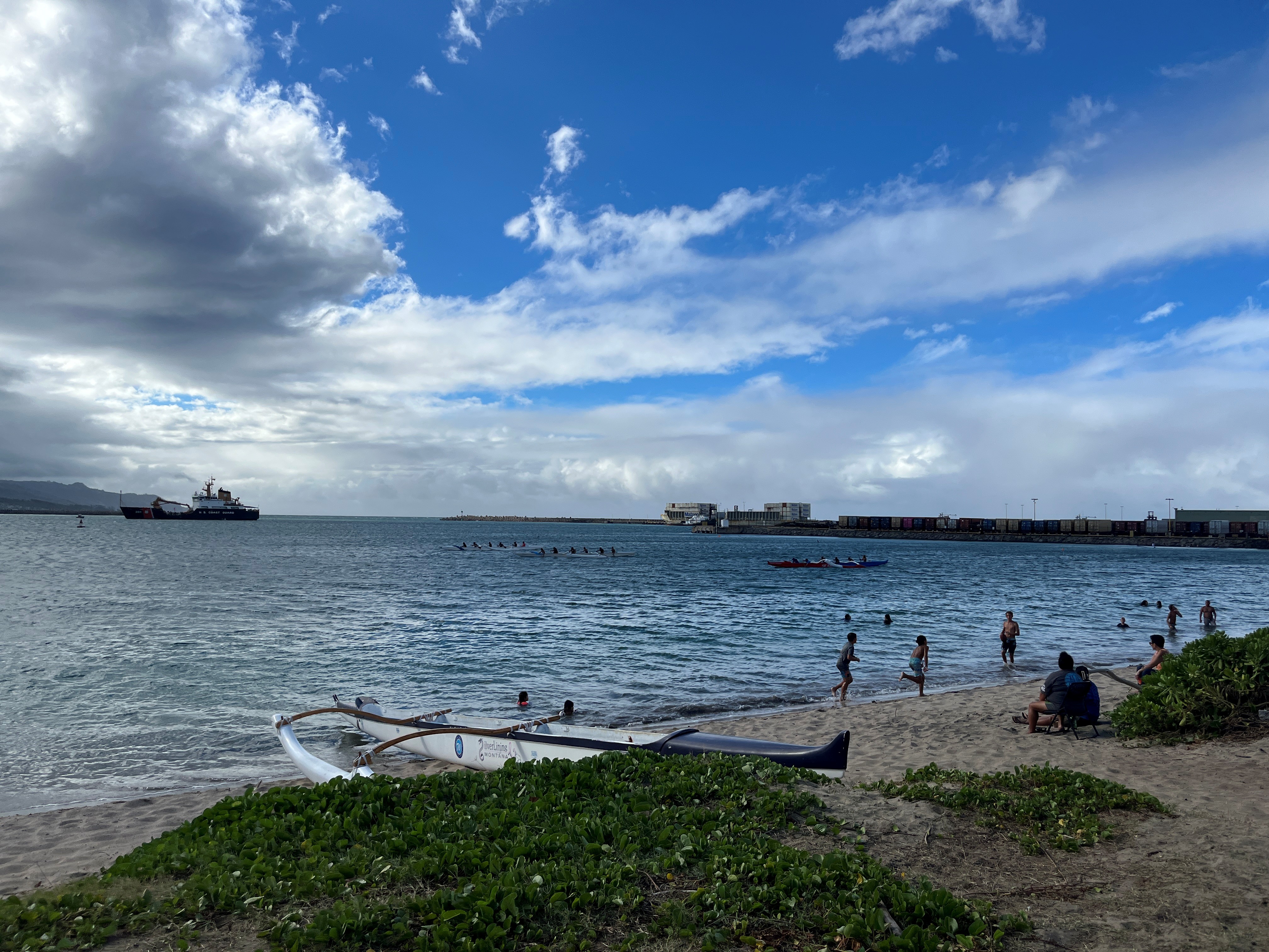
Figure CS2.1. Planning for Hoaloha Park addressed an active harbor with outrigger canoe clubs, wing foiling, and other water sports (photo courtesy Melissa May)
The decision context for this project was the need for an adaptation plan identified by an earlier countywide beach park vulnerability assessment (Maui 2022). The impetus was the County’s acquisition of two adjacent parcels, which provided opportunities to expand and adapt park facilities over time.
In 2023, the DPR contracted with a team of four consulting firms led by SSFM International with support from Integral Consulting, Brown & Caldwell, and Nohopapa Hawai‘i. Working with a $400,000 project budget, the consulting team led the planning process, designed and implemented community engagement, and prepared technical studies. The goal of the plan was to provide a roadmap for the future of this small urban beach park that would support the continuation of current uses, particularly Hawaiian canoe paddling and other water sports, while adapting the park facilities to future sea level rise, coastal hazards, and changing shoreline conditions.
The 18-month planning process (Figure CS2.2) addressed the core components of an adaptation pathway. Together with stakeholders, the planning team established a long-term vision and goals, defined criteria for acceptable levels of risk and disruption, identified and evaluated adaptation strategies, and developed a sequence of actions linked to future triggers and thresholds. Scope tasks included assembling and reviewing existing data and plans, conducting site-specific technical studies, engaging agency and community stakeholders to develop goals and criteria, identifying and evaluating adaptation strategies, and developing an implementation framework.
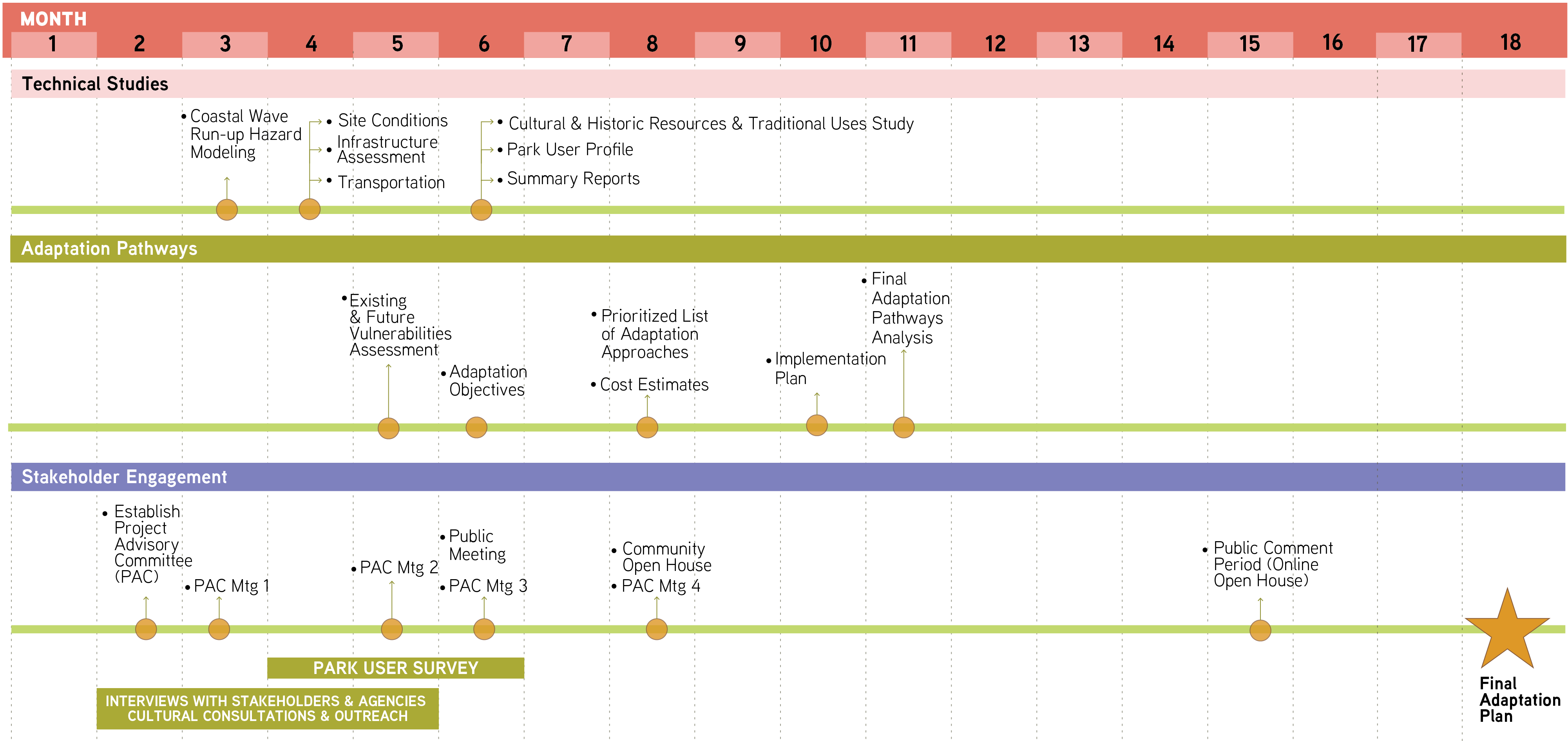
Figure CS2.2. Hoaloha Beach Park Adaptation Plan timeline (courtesy SSFM International)
The planning team conducted multiple technical studies for a comprehensive understanding of the project context:
- Coastal hazards, wave modeling, and vulnerability assessment
- Site conditions and infrastructure assessment
- Transportation and access assessment
- Cultural and historic resources and traditional uses assessment
- Park use and community needs assessment
- User value economic analysis
Robust stakeholder engagement throughout the project included the following elements:
- A stakeholder project advisory committee (PAC)
- Twelve agency and stakeholder meetings
- Cultural consultations
- An online, statistically valid park user survey (141 responses)
- Two community workshops
- Online public review of the draft plan (373 page views)
The first PAC meeting and community workshop included presentations on climate risks, coastal hazards, and early findings of the cultural and historic resources assessment. PAC and community members shared their own knowledge and lived experience as well as their hopes and aspirations for the park’s future. Together, stakeholders agreed on a long-term vision focused on maintaining the park as a hub for Hawaiian canoe paddling, traditional Hawaiian culture, community gathering, and water sports. The resulting goals centered on mitigating impacts of sea level rise over the long term to ensure safe current and future park use.
The project team used information from the technical studies and stakeholder engagement to assess vulnerabilities and opportunities and identify levels of acceptable or unacceptable disruption to park function. The park user survey was particularly valuable in understanding users’ needs, usage patterns, and priorities. The project team reviewed regional development plans and met with agencies and stakeholders for additional context.
Public feedback indicated strong preferences for nature-based strategies to mitigate beach erosion, including planting native vegetation to help maintain the dune. Residents also supported prioritizing shoreline access for the canoe clubs and other water sports users while adjusting beach access locations to minimize beach erosion and reduce user conflicts.
Drawing on these identified community priorities, operational needs, and feasibility determined by the technical studies, the team developed criteria to identify and evaluate potential short-, mid-, and long-term adaptation strategies. They presented these adaptation concepts to the PAC and to the public in a community workshop. Conceptual graphics showed how the park would change and adapt over time in response to sea level rise of up to six feet.
Based on the resulting stakeholder input, the planning team refined and prioritized the adaptation strategies and developed planning triggers and thresholds based on observable sea level rise and erosion impacts. One short-term strategy involved periodically relocating shower facilities to support sand deposition. Mid-term strategies were tied to the expiration of current canoe club leases, creating opportunities to consider when and where to relocate key canoe club infrastructure.
The resulting Hoaloha Park Adaptation Plan presents a long-term, phased approach to organizing future actions with implementation actions to guide investment, monitoring, and evaluation over time as hazards progress and site conditions change.
Funding Considerations for Adaptation Pathways
Funding for adaptation pathways approaches encompasses two distinct needs: funding for the process of adaptation pathway planning, and funding for implementation of pathways strategies and ongoing monitoring and evaluation.
Funding for Adaptation Pathway Planning
The process for funding adaptation pathway planning can vary. Ideally, a state, county, or municipal-level adaptation planning framework will identify a dedicated and sustainable funding source. The California Ocean Protection Council’s Senate Bill 1 (OPC SB 1) Grant Program integrates a funding stream with a state-level adaptation planning framework. Funds for local and regional governments to prepare sea level rise adaptation plans using the pathways approach are awarded through a noncompetitive application process, and governments with completed adaptation plans have priority access to implementation funds, available through a separate track of the OPC SB 1 grant program.
Adaptation planning can also be funded from departmental budgets, legislative appropriations, grants, or revenues from special improvement districts or impact fees. The City of Miami Beach’s Sea Level Rise Adaptation Plan (2025) was funded in part through a state-level Resilient Florida grant. As an example of a special-purpose revenue source, California’s SB 852 (2022) authorizes local jurisdictions to create Climate Resilience Districts for financing long-term climate adaptation strategies (Resnikoff 2026). By generating dedicated local revenue, these districts can support adaptation pathway planning, technical studies, and implementation over time. The Sonoma County Regional Climate Protection Authority was the first Climate Resilience District designated under the law (RCPA 2024). Similarly, in Hawai‘i, the state’s existing Special Improvement District authority was expanded in 2022 through Act 208 (SB 794) to allow counties to establish districts that can finance and coordinate climate change and sea level rise adaptation activities.
Funding for Pathway Implementation
Adaptation pathway implementation encompasses permitting, design, construction, maintenance, monitoring, and reporting for specific adaptation actions identified in a pathway. Many of these are capital improvements that can be funded through typical public agency budgeting processes, including the capital improvement program (CIP). A CIP plan typically spans four to 10 years and identifies a list of capital projects. Projects are reviewed and approved for the next year in the annual budget.
The annual planning and budgeting process is an excellent time for a city council or regional planning entity to reference adaptation strategies outlined in the adaptation pathway and determine whether a transition to the next phase of the pathway (or an alternative pathway) is necessary based on the predetermined triggers and thresholds. The California Adaptation Planning Guide recommends addressing priorities, funding, and scheduling of adaptation strategies in the CIP for projects requiring capital expenditures—for example, relocating a wastewater treatment facility or building a cooling center (California Governor’s Office of Emergency Services 2020).
Planners can apply general adaptation and resilience funding resources to adaptation pathway implementation. As the American Society of Adaptation Professionals’ Ready-to-Fund Resilience Toolkit (2022) notes, sources for resilience funding include public finance (taxes, fees, and charges at a municipal, agency, state, or federal level) or private finance (capital markets, bonds, investments, commercial bank loans, foundation funding, and other innovative funding arrangements). The ICLEI–Local Governments for Sustainability report Adaptation in Climate Planning and Implementation: Recommendations for U.S. Local Governments (2023) highlights the importance of seeking complementary approaches (commercial debt and equity, grants, concessional loans, subsidies, and other public support) and identifying partnerships with other departments, academic institutions, and special interest groups to tap into a wider array of funding sources.
Getting Started With Adaptation Pathways
Communities are at different stages in their adaptation planning journeys, and the actions needed to advance adaptation pathways will vary accordingly. In places with established climate adaptation frameworks, planners can integrate pathways into processes for climate adaptation plans and climate resilience components of comprehensive plans, regional plans, area plans, hazard mitigation plans, or functional plans. In places without an adaptation planning framework, planners can begin by building awareness of climate risks, identifying opportunities to incorporate pathway development into existing plans and planning processes, and advocating for broader climate adaptation frameworks.
Regardless of where a community begins, planners can play a central role in building awareness and capacity, coordinating partners, engaging communities, identifying funding sources, and establishing pathways as a recommended approach to support long-term, proactive decision-making for climate adaptation amid uncertainty.
Though adaptation pathways can seem complex, planners can begin with available climate information, asset and hazard data, community knowledge, and stakeholder priorities while identifying additional studies and resources needed. A pathways approach supports decision-making with incomplete information by establishing a process for learning, monitoring, and adjusting over time. The following steps provide a practical roadmap for developing an adaptation pathway.
1. Define the decision context and establish the scope and purpose of the pathway. Begin by clearly defining what decision the pathway will support. Identify the asset, system, place, or community being considered; the planning horizon; the decisions that need to be made; and the consequences of maintaining current approaches or delaying action. Identify key partners, decision-makers, and stakeholders. Develop a community engagement plan to integrate diverse perspectives and knowledge throughout pathway development.
Key questions include:
- What is being adapted, and why?
- What decisions need to be made now versus later?
- Who owns, manages, or is responsible for the asset(s) or system(s)?
- Who else has a stake in the outcome of the pathway?
- What conditions would indicate that current approaches are no longer effective?
2. Establish an understanding of existing conditions and future risks. Gather available information about current conditions, historical changes, and future climate risks, including climate projections, hazard data, asset information, environmental conditions, stakeholder knowledge, and existing plans or studies. Conduct site-specific analyses, including hazard modeling, asset inventories, and vulnerability assessments, to enhance accuracy and understanding of risks and impacts. Validate this information with stakeholders and add their input and lived experience. Incorporate Indigenous perspectives and traditional ecological knowledge.
Key questions include:
- What hazards and climate impacts are affecting or expected to affect this place or system?
- How have conditions changed over time?
- Which assets, communities, ecosystems, or services are most exposed?
- What could future impacts look like?
- What information gaps need to be addressed?
3. Define long-term goals and acceptable levels of risk. Work with decision-makers and stakeholders to establish what the pathway should achieve. Goals should describe desired future conditions and help define acceptable levels of disruption, damage, or service loss.
Examples of goals may include:
- Maintaining transportation access and emergency response routes
- Protecting critical infrastructure functions
- Preserving public access and cultural resources
- Reducing risks to vulnerable communities
- Maintaining ecosystem functions and natural buffers
Key questions include:
- What outcomes are we trying to achieve over the long term?
- What conditions would be unacceptable?
- What values and priorities should guide adaptation decisions?
4. Identify and evaluate potential adaptation strategies. Develop a range of possible adaptation strategies that reduce risk while preserving future options, including near-term actions, longer-term transitions, and alternative approaches.
Strategies may include:
- Maintenance and operational changes
- Nature-based solutions
- Elevation, retrofit, hardening, or protection measures
- Changes to land use, regulations, or development standards
Evaluate strategies using criteria such as:
- Effectiveness under different climate scenarios
- Feasibility and implementation constraints
- Community acceptance and alignment with defined goals
- Costs and funding needs
- Environmental and social impacts
- Equity considerations
- Potential for unintended consequences or maladaptation
5. Identify triggers, thresholds, and decision points. Translate climate risks and potential impacts into measurable triggers and thresholds that will guide decisions about how to adapt and when. Triggers indicate when conditions are changing; thresholds identify when an adaptation strategy is no longer meeting goals and a transition to another action should occur.
Examples include:
- Frequency or severity of flooding events
- Rates of shoreline erosion
- Loss of infrastructure performance
- Damage to structures
- Diminished public access or uses (e.g., recreational, cultural, economic)
- Increased maintenance needs or costs
- Declining service levels
- Habitat or ecosystem changes
Determine the lead time needed to plan, permit, fund, and implement future actions before unacceptable impacts occur.
6. Develop and visualize the adaptation pathway. Organize strategies into a sequence of actions showing what can happen now, what actions may be needed later, and what conditions would prompt a transition. Use pathway diagrams, decision trees, timelines, or other visual tools to communicate the sequence of decisions to stakeholders and decision-makers.
A completed pathway should show:
- Current conditions and near-term actions
- Alternative future strategies and actions
- Triggers and thresholds for changing course
- Lead times for future decisions and actions
- Relative or order-of-magnitude costs
Supplemental information can include:
- Monitoring needs and responsible parties
- Technical studies necessary to inform the next phase
- Trade-offs or co-benefits related to valued resources, uses, infrastructure, and development
- Funding streams
A Sample Pathway for a Coastal Road
Figure 4 presents a sample adaptation pathway for a hypothetical coastal road that currently floods several times yearly.
Goal: Maintain long-term roadway safety and functionality with minimal disruption.
Near-term adaptation strategy: Improve drainage and monitoring.
Trigger: Roadway flooding exceeds six closures per year.
Mid-term adaptation strategy: Raise sections of roadway.
Threshold: Roadway overtopped during annual king tides.
Long-term adaptation strategy: Raise entire roadway or relocate roadway inland.
The pathway identifies and evaluates these actions in advance, allowing agencies to prepare funding, permitting, and community engagement before conditions become unacceptable.
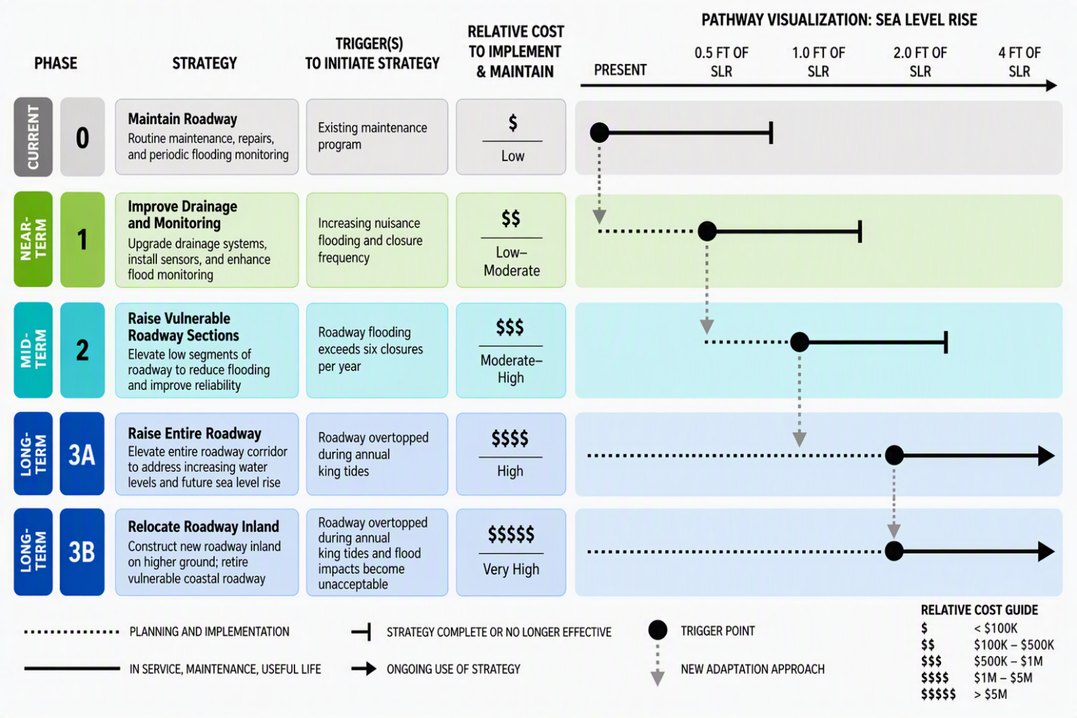
Figure 4. A sample adaptation pathway for a coastal road (courtesy Melissa May)
7. Integrate the pathway into plans, policies, budgets, and implementation processes. Identify where to incorporate pathway recommendations, such as capital improvement programs, asset management systems, comprehensive plans, facility plans, design standards, permitting processes, or operational procedures.
Work with implementing agencies to identify:
- Funding sources
- Responsible agencies or departments
- Implementation schedules
- Permitting requirements
- Coordination needs
- Monitoring responsibilities
8. Establish monitoring and revisit the pathway over time. Establish a process for tracking climate conditions, asset performance, implementation progress, and new scientific information.
Define:
- What indicators will be monitored
- Who is responsible for monitoring and reporting
- How often the pathway will be reviewed
- How decisions will be revisited when triggers or thresholds are reached
The sidebar above provides an example and visualization of a sample adaptation pathway created for a hypothetical coastal road subject to flooding. For further guidance, additional resources on developing and implementing adaptation pathways are listed in the sidebar below.
Additional Adaptation Pathways Resources
Along with the federal and state guidelines referenced earlier, the resources below provide guidance, tools, and examples to help planners understand and apply adaptation pathways in practice.
“Adaptation Pathways for Climate Resilience” (PAS QuickNotes 115). A concise overview of the adaptation pathways approach, including key concepts, development steps, and planning applications. Useful for planners to learn the basics and share with clients and colleagues to develop understanding of the pathways concept and its applications.
Adaptation Pathways for Infrastructure Operators and Policymakers (University of Birmingham/Tyndall Centre for Climate Change, 2021). An introduction to adaptation pathways for infrastructure systems from the UK, covering adaptation tipping points, decision triggers, and sequencing actions over time to manage climate uncertainty and maintain system performance. Useful for planners working with long-lived infrastructure assets and capital investments.
Adaptation Roadmap: A Practitioner’s Guide to Plan and Implement a Collaborative, Equitable, Integrative, and Flexible Approach for Sea Level Rise Adaptation (Bay Conservation and Development Commission, 2022). A practitioner-focused resource that provides an accessible overview and detailed guidance for collaboratively developing equitable, flexible sea level rise adaptation pathways that reduce flood risk and support informed community decision-making.
Implementing the Steps to Resilience: A Practitioner’s Guide (National Oceanic and Atmospheric Administration (NOAA), 2022). A step-by-step resilience planning framework covering risk assessment, adaptation strategy development, and implementation. Supports adaptation pathways planning by providing methods for evaluating risks, selecting actions, and monitoring changing conditions.
U.S. Climate Resilience Toolkit (NOAA Climate Program Office). A national collection of climate data, planning frameworks, tools, and case studies that support resilience planning. Provides resources and examples that can inform pathway development and adaptive decision-making.
Conclusion
Climate change is reshaping the conditions under which communities plan, invest, and make decisions about development, infrastructure, and natural resources. Uncertainty around the timing, severity, and consequences of climate impacts requires planners to move beyond traditional predict-and-plan approaches and find ways to incorporate uncertainty into planning processes while still supporting proactive decision-making. Adaptation pathways provide planners with a practical framework for navigating uncertainty by anticipating future climate-related impacts, linking them with near-term decisions, and providing a flexible and phased roadmap for adaptation that is grounded in science and aligned with community priorities.
Planners are uniquely positioned to advance the pathways approach because they help communities define desired futures, evaluate tradeoffs, coordinate across disciplines and jurisdictions, and connect long-range resilience goals to today’s decisions. By incorporating adaptation pathways into planning processes, capital investments, infrastructure decisions, and community engagement efforts, planners can help communities avoid maladaptation, preserve future options, and ensure that limited resources are invested in adaptation strategies that provide lasting benefits for community resilience.
About the Authors
Melissa May, AICP, is a principal at Integral Consulting with more than 20 years of experience advancing climate resilience across built environments. She has partnered with state and local planning and infrastructure agencies on a wide range of climate resilience initiatives. She has served as lead planning consultant on 11 APA award-winning projects, three of which received National APA awards.
Alice McLean, AICP, is a planner with SSFM International. Her experience spans coastal resilience planning, conservation, ecosystem restoration, and community engagement. In her current role, she has contributed to adaptation plans in response to sea level rise, compound flooding, and heat; policy analysis for climate adaptation, managed retreat, and land use regulations; and long-range community plans.
The authors would like to thank David L. Revell, PhD, and Matthew Jamieson for their contributions and technical review.
David L. Revell, PhD, is a principal at Integral Consulting with more than 30 years of experience in coastal resilience, adaptation planning, and surf science. His work integrates geomorphology, historic ecology, coastal hazard modeling, and socioeconomic analysis to help communities evaluate adaptation pathways and navigate trade-offs among infrastructure protection, coastal access, beaches, ecosystems, and recreation.
Matthew Jamieson is a consultant at Integral Consulting. He applies expertise in GIS, coastal hazard analysis, and visual communication to help stakeholders understand future risks, evaluate alternative adaptation options, and identify implementation pathways. He has supported adaptation planning and resilience initiatives throughout Hawai‘i and California.
References
American Society of Adaptation Professionals. 2022. Ready-to-Fund Resilience Toolkit.
Anning, Dave, Bella Bonner, Shaun Burns, et al. 2025. Climate Vulnerability of California’s Natural Surfing Capital: Insights on Surfonomics and Surf Break Vulnerability from Santa Cruz for Local and Statewide Consideration. Save the Waves Coalition.
Barnett, Jon, Sonia Graham, Colette Mortreux, Ruth Fincher, Elissa Waters, and Anna Hurlimann. 2014. "A Local Coastal Adaptation Pathway." Nature Climate Change 4 (12): 1103–08. https://doi.org/10.1038/nclimate2383.
Bloemen, Pieter, Tim Reeder, Chris Zevenbergen, Jeroen Rijke, and Ashley Kingsborough. 2017. "Lessons Learned from Applying Adaptation Pathways in Flood Risk Management and Challenges for the Further Development of This Approach." Mitigation and Adaptation Strategies for Global Change 23: 1083–1108. https://doi.org/10.1007/s11027-017-9773-9.
California Department of Transportation (Caltrans). 2026. Updated Guidance on Incorporating Sea-Level Rise.
California Department of Water Resources. 2025. State Water Project Adaptation Strategy: Reducing Vulnerabilities to Climate Change.
California Governor’s Office of Emergency Services. 2020. California Adaptation Planning Guide.
California Ocean Protection Council. 2024. State of California Sea Level Rise Guidance: 2024 Science and Policy Update.
———. 2026. Sea Level Rise.
California Office of Planning and Research. 2024. California Climate Adaptation Strategy.
Carmel-by-the-Sea (California), City of. 2026. Coastal Adaptation Project and Sea Level Rise Update.
Cesanek, William, Vicki Elmer, and Jennifer Graeff. 2017. Planners and Water. PAS Report 588. Chicago: American Planning Association.
Coulter, Liese. 2019. Climate Change Adaptation Pathways Framework: Supporting Sustainable Local Food in B.C. Prepared for the B.C. Ministry of Agriculture through the 2018-19 Mitacs Science Policy Fellowship. Victoria, British Columbia.
Denver, City and County of, Department of Transportation and Infrastructure. 2026. Denver One Water Program.
Federal Highway Administration (FHWA). 2016. TEACR Engineering Assessment: Adaptation Decision-Making Assessment Process (ADAP). FHWA-HEP-17-004. September.
Ferranti, Emma, Sarah Greenham, and Ruth Wood. 2021. Adaptation Pathways for Infrastructure Operators and Policy Makers: A Briefing Note. University of Birmingham, UK.
Fort Collins (Colorado), City of. 2025. One Water Action Framework. March.
Haasnoot, Marjolijn, Valeria Di Fant, Jan Kwakkel, and Judy Lawrence. 2024. "Lessons from a Decade of Adaptive Pathways Studies for Climate Adaptation." Global Environmental Change 88: 102907. https://doi.org/10.1016/j.gloenvcha.2024.102907.
Haasnoot, Marjolijn, Jan H. Kwakkel, Warren E. Walker, and Judith ter Maat. 2013. “Dynamic Adaptive Policy Pathways: A Method for Crafting Robust Decisions for a Deeply Uncertain World.” Global Environmental Change 23(2): 485–98. https://doi.org/10.1016/j.gloenvcha.2012.12.006.
Haasnoot, Marjolijn, Andrew Warren, and Jan H. Kwakkel. 2019. “Dynamic Adaptive Policy Pathways (DAPP).” Pages 71–92 in Decision Making Under Deep Uncertainty, edited by Vincent Marchau, Warren Walker, Peter Bloemen, and Steven Popper. Springer, Cham. https://doi.org/10.1007/978-3-030-05252-2_4.
Hamilton, Anna, Michelle Ryan, Emily Eisenhauer, Roxolana Kashuba, and Candace May. 2025. A Summary of Adaptation Pathways Approaches. EPA/600/S-25/239. Washington, D.C.: U.S. Environmental Protection Agency.
Hawaiʻi Office of Planning and Sustainable Development (OPSD). 2026. Research, Analysis and Feasibility of Managed Retreat in Hawaiʻi.
Honolulu (Hawaiʻi), City and County of. 2024. Climate Ready Oʻahu.
ICLEI–Local Governments for Sustainability. 2023. Adaptation in Climate Planning and Implementation: Recommendations for U.S. Local Governments.
Integral Consulting. 2026. Carmel Adaptation Pathways: Adaptation Alternatives, Priorities, and Triggers. Prepared for the City of Carmel-by-the-Sea, California. May.
Jacobs, Brent, Louise Boronyak, and Polly Mitchell. 2019. “Application of Risk-Based, Adaptive Pathways to Climate Adaptation Planning for Public Conservation Areas in NSW, Australia.” Climate 7(4): 58. https://doi.org/10.3390/cli7040058.
Kaczorowski, Mary Rose. 2026. “What Will Tomorrow’s Redwood Forest Look Like?” The Mendocino Voice, July 19.
Kingsborough, Ashley, Katie Jenkins, and Jim W. Hall. 2017. “Development and Appraisal of Long‑Term Adaptation Pathways for Managing Heat‑Risk in London.” Climate Risk Management 16: 73–92. https://doi.org/10.1016/j.crm.2017.01.001.
Kwadijk, Jaap C.J., Marjolijn Haasnoot, Jan P.M. Mulder, et al. 2010. “Using Adaptation Tipping Points to Prepare for Climate Change and Sea Level Rise: A Case Study in the Netherlands.” Wiley Interdisciplinary Reviews: Climate Change 1(5): 729–40. https://doi.org/10.1002/wcc.64.
Lawrence, Judy, and Marjolijn Haasnoot. 2017. “What It Took to Catalyse Uptake of Dynamic Adaptive Pathways Planning to Address Climate Change Uncertainty.” Environmental Science & Policy 68: 47–57. https://doi.org/10.1016/j.envsci.2016.12.003.
Lin, Brenda B., Tim Capon, Art Langston, et al. 2017. “Adaptation Pathways in Coastal Case Studies: Lessons Learned and Future Directions.” Coastal Management 45(5): 384–405. https://doi.org/10.1080/08920753.2017.1349564.
Los Angeles County Metropolitan Transportation Authority. 2019. Climate Action and Adaptation Plan.
Marchau, Vincent A. W. J., Warren E. Walker, Pieter J. T. M. Bloemen, and Steven W. Popper, editors. 2019. Decision Making under Deep Uncertainty: From Theory to Practice. Springer Cham. https://doi.org/10.1007/978-3-030-05252-2.
Maui, County of, Department of Parks and Recreation. 2022. Beach Parks Vulnerability and Adaptation Study.
———. 2025. Hoaloha Park Adaptation Plan.
May, Melissa. 2025. “Adaptation Pathways for Climate Resilience.” PAS QuickNotes 115.
Miami Beach (Florida), City of. 2025. Sea Level Rise Adaptation Plan.
Millar, Constance I., Nathan L. Stephenson, and Scott L. Stephens. 2007. “Climate Change and Forests of the Future: Managing in the Face of Uncertainty.” Ecological Applications 17(8): 2145–2151. https://doi.org/10.1890/06-1715.1
New York City. 2025. East Side Coastal Resiliency.
New York City Mayor’s Office of Climate and Environmental Justice. 2022. Climate Resiliency Design Guidelines 4.1.
Nikkels, Melle J., Saideepa Kumara, and Holger Meinkea. 2019. “Adaptive Irrigation Infrastructure—Linking Insights from Human-Water Interactions and Adaptive Pathways.” Current Opinion in Environmental Sustainability 40: 37–42. https://doi.org/10.1016/j.cosust.2019.09.001
One Water Honolulu. 2026. One Water Honolulu: Collaborating for a Thriving and Resilient O’ahu.
Paveglio, Travis B., Annie Schmidt, and Michelle Medley-Daniel. 2024. “The Fire Adapted Communities Pathways Tool: Facilitating Social Learning and a Science of Practice.” Journal of Forestry 122(2): 194–205. https://doi.org/10.1093/jofore/fvad044.
Portland, City of. 2026. One Water: Integrating Water, Sewer, and Stormwater Services.
Ranger, Nicola, Tim Reeder, and Jason Lowe. 2013. “Addressing ‘Deep’ Uncertainty Over Long-Term Climate in Major Infrastructure Projects: Four Innovations of the Thames Estuary 2100 Project.” EURO Journal on Decision Processes 1(3-4): 233–62. https://doi.org/10.1007/s40070-013-0014-5.
Rebuild by Design. 2025. Project Pages: The Big U.
Reeder, Tim, and Nicola Ranger. 2011. How Do You Adapt in an Uncertain World?: Lessons From the Thames Estuary 2100 Project. World Resources Report, Washington, D.C.
Rosenzweig, Cynthia, William D. Solecki, Reginald Blake, et al. 2011. “Developing Coastal Adaptation to Climate Change in the New York City Infrastructure-Shed: Process, Approach, Tools, and Strategies.” Climatic Change 106(1): 93–127. https://doi.org/10.1007/s10584-010-0002-8.
Rosenzweig, Cynthia, and William Solecki. 2014. “Hurricane Sandy and Adaptation Pathways in New York: Lessons from a First-Responder City.” Global Environmental Change 28: 395–408. https://doi.org/10.1016/j.gloenvcha.2014.05.003.
San Francisco Bay Conservation and Development Commission (BCDC). 2024. Regional Shoreline Adaptation Plan: One Bay Vision, Strategic Regional Priorities, and Subregional Shoreline Adaptation Plan Guidelines. December.
San Francisco Planning Department. 2021. Islais Creek Southeast Mobility and Adaptation Strategy.
San Francisco Public Utilities Commission. 2025. OneWaterSF.
Santa Cruz (California), City of. 2021. West Cliff Drive Adaptation and Management Plan: A Public Works Plan.
Tanaka, Akemi, Kiyoshi Takahashi, Yuji Masutomi, et al. 2015. “Adaptation Pathways of Global Wheat Production: Importance of Strategic Adaptation to Climate Change.” Scientific Reports 5: 14312. https://doi.org/10.1038/srep14312.
The Netherlands. 2010. The 2011 Delta Programme. Ministry of Transport, Public Works and Water Management; Ministry of Agriculture, Nature and Food Quality; Ministry of Housing, Spatial Planning and the Environment. September.
———. 2026. National Delta Programme.
UK Environment Agency. 2026. Collection: Thames Estuary 2100 (TE2100).
Walker, Warren E., Robert J. Lempert, and Jan H. Kwakkel. 2013. “Deep Uncertainty.” Pages 395–402 in Encyclopedia of Operations Research and Management Science, third edition, edited by Saul Gass and Michael Fu. Springer Cham. https://doi.org/10.1007/978-1-4419-1153-7_1140.
Wall, Thomas A., Warren E. Walker, Vincent A. W. J. Marchau, et al. 2015. “Dynamic Adaptive Approach to Transportation-Infrastructure Planning for Climate Change: San-Francisco-Bay-Area Case Study.” Journal of Infrastructure Systems 21(4). https://doi.org/10.1061/(ASCE)IS.1943-555X.0000257.
Weaver, Christopher P., Robert J. Lempert, Casey Brown, et al. 2013. “Improving the Contribution of Climate Model Information to Decision Making: The Value and Demands of Robust Decision Frameworks.” Wiley Interdisciplinary Reviews: Climate Change 4(1): 39–60. https://doi.org/10.1002/wcc.202.
Werners, Saskia E., Russell M. Wise, James R.A. Butler, et al. 2021. “Adaptation Pathways: A Review of Approaches and a Learning Framework.” Environmental Science & Policy 116: 266–75. https://doi.org/10.1016/j.envsci.2020.11.003.
Page 3 icons courtesy of Hanbai, Resa Valen, Sulistiana, Nuricon, heri kusyanto, Eklip Studio, Jamil Akhtar/The Noun Project.
PAS Practical Guidance: Planning in Action 1 | October 2026. ©2026 American Planning Association. All Rights Reserved. Planning in Action (ISSN pending) is a publication of the APA Knowledge Team at the American Planning Association, 200 E. Randolph Street, Suite 6900, Chicago, IL 60601-6909; planning.org. Ann Dillemuth, AICP, Editor. Petra Hurtado, PhD, Chief Foresight and Knowledge Officer.